If you would like to request a Spanish interpretation, please email cdphe_apcd_outreach@state.co.us
Si desea solicitar interpretación al español, envíe un mensaje por correo electrónico a cdphe_apcd_outreach@state.co.us
Accessibility statement and support
Showing posts with label Prescribed Burning Information. Show all posts

Tuesday, May 27, 2025

San Juan National Forest Prescribed Fire- May 27, 2025

The San Juan National Forest is planning a large broadcast burn on Tuesday, May 27 near Dolores, Colorado. Smoke may be visible in Dolores, Mancos, and on highways US-160, US-491, CO-145 and CO-184.

Although no major public health impacts are expected, people who are unusually sensitive to particle pollution may want to consider reducing prolonged or heavy exertion. You can find more information on how to protect your health on CDPHE's website.

More information on this burn is available on the Prescribed Fire Map and InciWeb.

Map of San Juan National Forest. Area highlighted in yellow north of Dolores, CO is planned to burn on Tuesday, May 27.
Map of the San Juan National Forest Haycamp Mesa Prescribed Fire Area. The area highlighted in yellow denotes the location of planned ignitions on Tuesday, May 27, 2025.


Friday, May 23, 2025

Prescribed burning operations west of Colorado Springs

A prescribed burn is taking place on Friday, May 23rd near Rainbow Gulch, west of Rampart Reservoir. Smoke from this operation may be visible from areas in and near Colorado Springs. For more information, please refer to the Pikes-San Isabel National Forest X page. No public health impacts are expected, however information on smoke & your health can be found on the CPDHE information page.

Thursday, May 15, 2025

Prescribed burn operations planned for Friday, May 16th in Boulder County

Arapaho and Roosevelt National Forest managers are planning burning operations in the Forsythe II Prescribed Burn area, located 7 miles southwest of Boulder and 5 miles east of Nederland on Friday, May 16th. This portion of the Forsythe II project may burn around 125 acres. Smoke from this operation may be visible from areas along the Front Range, including Boulder, Superior, Broomfield, and surrounding areas. While smoke impacts are expected to be minimal to the public, information on how to protect your health can be found on CDPHE's Wood smoke and your health webpage.

Tuesday, April 29, 2025

Large broadcast burn on Tuesday in southwestern Colorado

 A large broadcast burn will be taking place today in Montezuma County, approximately 8 miles to the northeast of Dolores in southwestern Colorado.  Approximately 1200 acres are planned on being burned, so smoke will certainly be visible throughout the region including from Dolores, Mancos, and possibly Cortez.  Although the burn is fairly remote, some periodic smoke impacts will be possible for downwind locations Tuesday afternoon to the north and northeast of the fire in the Bald Hill and Taylor Mesa areas.  Heavier smoke will be possible overnight Tuesday night and into early Wednesday morning along Highway 145 near the fire, and also southward along the Dolores River.  It is unclear if smoke will reach Dolores overnight, but residents there should strongly consider closing their windows before going to sleep Tuesday night.  Additional ways to protect your health can be found at CDPHE's Wood smoke and your health webpage.  More information about this and other prescribed burns within the Dolores Ranger District can be accessed at the 2025 San Juan National Forest Prescribed Fire Program Inciweb page.


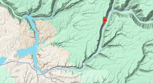
Location of a prescribed fire taking place on Tuesday to the northeast of Dolores, Colorado
Location of Tuesday's prescribed fire to the northeast of Dolores, Colorado


Monday, April 14, 2025

Monday prescribed fires

 Two large prescribed burns are on the calendar for Monday.  The Sunnyside controlled burn is taking place in Pitkin County with smoke likely visible today in Aspen.  In Larimer County, there is another round of burning in the Red Feather Lakes area. Any impacts from smoke should be fairly minimal around these two burns, but locally heavy smoke will not be out of the question (particularly overnight Monday night and early Tuesday morning).  For information on how to protect your health, please visit CDPHE's Wood smoke and your health webpage.  You can also see where prescribed fires are scheduled this week on the CDPHE prescribed fire map.

Wednesday, March 26, 2025

Heavy smoke near Red Feather Lakes

 If you are planning on spending some time around Red Feather Lakes in Larimer County Wednesday morning, you may want to limit outdoor time for at least a few hours.  A 400 acre prescribed burn yesterday has produced some areas of heavy smoke this morning.  Fortunately, smoke levels are decreasing and improved air quality is expected later Wednesday morning and into the afternoon hours.  There will be some more burning in the area today, but at a much more limited scale.  Do keep in mind that smoke may be present again Thursday morning.  

Click here for more information on the Magic Feather Prescribed Burn 

Click here for the EPA's Fire and Smoke Map

Click here for information on how to protect yourself from wood smoke

A map showing an air quality monitor registering heavy smoke in the Red Feather Lakes area
An air quality monitor indicating heavy smoke (in dark red) to the east-southeast of a prescribed fire in the Red Feather Lakes area.  Data provided from EPA's Fire and Smoke Map


Tuesday, March 25, 2025

Spring Broadcast Burning

 We are entering the time of year where snow is decreasing across the state and fuels (grass, brush, etc.) are drying out, but are not dry enough (in most cases) to be a significant wildfire threat.  During this time window, conditions can become favorable for broadcast/landscape burning.  Several broadcast projects are scheduled for this week, including near Red Feather Lakes, Hudson/Keenesburg, and Alamosa.  You can stay up-to-date on the schedule of all large permitted broadcast burns at CDPHE's prescribed fire map

Firefighters maintaining the Green Mountain prescribed fire
Green Mountain Prescribed Fire
June 5, 2024
Pike & San Isabel National Forests


Monday, November 18, 2024

It's pile burning season!

 As we enter the winter months, the burning of piles becomes much more common across Colorado.  Snowstorms are a great time to effectively burn piles while also decreasing the amount of smoke that could cause public health issues.

Although there are several pile projects currently underway, one of the biggest ones is scheduled to start on Tuesday if conditions are optimal for burning.  It will be taking place near Keystone in Summit County where they could burn up to 900 piles on Tuesday, and perhaps additional piles on Wednesday.  Smoke will no doubt be visible in the area, including the nearby stretches of Interstate 70 and Highway 9, and the communities of Breckenridge, Silverthorne, Dillon and Frisco.

More information on pile burning in this part of Colorado can be found at the White River National Forest website.  You can also learn more about pile burning in Summit County with this video. Additionally, you can check the status of prescribed burns all across Colorado with CDPHE's prescribed fire map.  And finally, learn how you can help protect your health from woodsmoke at CDPHE's wood smoke and your health webpage.

Monday, September 9, 2024

Prescribed fires expected this week

 As we head into the autumn months and the threat for wildfires decreases, expect to see an increase in prescribed fire activity across the state.  This is especially true with larger landscape burns that often occur during the early autumn months before the snow starts to fly.

This week, some sizable broadcast burns are expected in the southwestern part of Colorado.  The US Forest Service will be conducting a 1000+ acre burn today between Chimney Rock and Arboles (see map below).  Due to the remote location of this burn, public health impacts are not anticipated.  However smoke will likely be visible today on that section of State Highway 151.  You can find more details on this burn and additional information from the San Juan National Forest at InciWeb.  The southwest district of the Bureau of Land Management will also be conducting prescribed burns this month in southwestern Colorado.

Please be sure to stay up-to-date on all the larger burns that will be conducted across Colorado over the coming months by clicking the Prescribed Fire Map tab above.  You can view all the current smoke management permits for this calendar year along with weekly burn notifications.

A map showing the location of a prescribed burn between Chimney Rock and Arboles, Colorado
Location of the "Southern HDs" prescribed burn in southwest Colorado

Thursday, June 13, 2024

Prescribed fire near Monument continues on Thursday

 The US Forest Service is continuing a prescribed burn project on Thursday with a treatment of up to 400 acres possible.  There have been some heavy smoke impacts from Wednesday's burn on areas just to the east of the burn site in western parts of the Monument area.  Fortunately that smoke is starting to clear out Thursday morning, though another round of smoke will be possible later today and early Friday morning.  For residents in this area, please keep windows close when smoke is present and avoid or reduce any strenous activities.

Picture of smoke lofting into the sky from the Monument prescribed burn.
Smoke from the Monument prescribed fire on June 12, 2024


Wednesday, June 5, 2024

Prescribed Fire near Green Mountain

 A prescribed fire is taking place today near Green Mountain in the Pike-San Isabel National Forest. No major public health impacts are expected from this fire, but smoke may be visible as far away as Chatfield State park on Wednesday evening through Thursday morning. In areas where smoke is present, unusually sensitive people should consider reducing prolonged or heavy exertion.


Monday, May 20, 2024

Prescribed Burning near Gross Reservoir

The US Forest Service conducted a 70 acre prescribed burn on Sunday in the vicinity of Gross Reservoir in Boulder County.  Although no additional ignitions are expected for the next several days, lingering smoke will be likely in the area.  

Sign up here for email updates regarding this burn.

Additional information about the Forsythe II prescribed burn can be found here on InciWeb.

A map of the Forsythe II prescribed burn area near Gross Reservoir in Boulder County, Colorado
 Map of the Forsythe II Prescribed Burn area. Image courtesy of US Forest Service.

Tuesday, April 23, 2024

Prescribed Burning Operations taking place in eastern La Plata County, 4/23/24

 A large prescribed burning operation is taking place on Tuesday, April 23, 2024 in La Plata County, just east of Bayfield. Smoke from this operation may be visible from locations near Highway 160 in eastern La Plata County and western Archuleta County. No significant public health impacts are currently expected.

Monday, April 15, 2024

Prescribed Burning in Arapaho Roosevelt National Forest, week of 4/15

This week, a prescribed burn is anticipated to take place in the Forsythe II burn area, west of Gross Reservoir in western Boulder County. While no major public health impacts are expected, smoke may be visible in nearby locations. Unusually sensitive people should consider reducing prolonged or heavy exertion in areas where smoke is visible.

Updates on this burn will be posted to InciWeb.


Broadcast burn on a slope with coniferous trees in the background
Broadcast burning is taking place at the Forsythe II burn area. Image courtesy of US Forest Service.