If you would like to request a Spanish interpretation, please email cdphe_apcd_outreach@state.co.us
Si desea solicitar interpretación al español, envíe un mensaje por correo electrónico a cdphe_apcd_outreach@state.co.us
Accessibility statement and support

Friday, June 27, 2025

Smoke impacts in Colorado will vary by location on Friday

There is a lot gong on with regard to wildfires and smoke this morning. We have 2 wildfires burning in Colorado, and additional smoke being transported from out-of-state fires. Lets dig in.

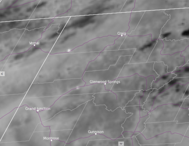
Early morning satellite imagery shows smoke and haze in many areas. Notable concentrations of smoke can be seen in valleys and lower-lying terrain on the western slope and northern mountain areas. Additional haze can be seen spilling over to areas of the Front Range. Three areas will see impacts from smoke, each to varying degrees.

Satellite image, courtesy CIRA/CSU, shows wildfire smoke in areas of northern Colorado on Friday morning. Smoke is seen in valley areas and low-lying terrain, as well as dispersed concentrations of smoke across larger areas, including the northern Front Range region. Time of image is 7:40 am MDT on 6/27/2025.

The greatest impacts from smoke will be experienced in locations near the Hilltop Fire in Garfield County. An Air Quality Health Advisory for Wildfire Smoke has been issued for areas along and near the Colorado River and I-70, from Parachute to Rulison. Smoke is expected to linger along the valley floor in this area, producing the highest concentrations of smoke during overnight and early morning hours. As daytime mixing and winds increase, smoke concentrations may decrease somewhat during the afternoon and evening hours. Folks in this area should remain aware of current and changing conditions in order to reduce exposure and potential health impacts from smoke.

Google maps image shows the general area of the Air Quality Health Advisory for Wildfire Smoke and the location of the Hilltop fire near Rulison, CO on Friday June 27, 2025.
Google maps image shows the general area of the Air Quality Health Advisory for Wildfire Smoke, and the location of the Hilltop Fire near Rulison, CO on Friday June 27, 2025.

The second area of interest for smoke impacts is in southwestern Moffat County in northwest Colorado, due to the Horse Draw fire. This fire is located in a mainly rural area of Moffat County along Highway 40, northeast of Rangely, CO. Broad public health impacts from this fire are not expected. However, higher amounts of smoke are possible in close proximity to the fire and the transport of smoke may cause hazy skies and light to moderate concentrations of fine particulates in downwind areas. These effects may reach communities such as Craig, Hayden, and Steamboat Springs. 

Lastly, there is a broad potential for the influence from smoke over large areas of northern portions of Colorado, including the northern Front Range region. Concentrations of fine particulates (smoke) are expected to remain Good to Moderate in most areas on Friday, however we will keep a close watch on air quality conditions for any potential changes. 

As always, we urge people in all areas to take appropriate measures to reduce exposure to smoke and protect your health. Information can be found on our wildfire smoke and health webpage to help decide which measures are right for you.

We will continue to provide further information and updates on all of these situations as they develop.

Thursday, June 26, 2025

2 new starts in Colorado

Two new fires have emerged on Thursday. The Hilltop fire is located in south central Garfield County, near Rulison, CO. The Horse Draw fire is in southwest Moffat County, northeast of Rangely, CO.  Information is limited on both of these fires, including location, size estimates, and extent of air quality impacts. However it is expected that areas near these fires will be impacted by moderate to heavy amounts of smoke. 

In areas near these fires, including along I-70 near Rulison, CO and along Highway 40 southwest of Maybell, CO, people who are sensitive to smoke should consider reducing exertion, and take measures to limit exposure to smoke. Health information and tips on reducing exposure can be found on CDPHE's webpage about wildfire smoke and health.


Map of northwest Colorado showing a satellite image indicating two new wildfires, 1 in southwest Moffat County and one in south central Garfield County. Image time is 6:20 pm MDT, Thursday June 26th.
Map of northwest Colorado showing a satellite image indicating two new wildfires, one in southwest Moffat County and one in south central Garfield County. Image time is 6:20 pm MDT, Thursday June 26th. Image credit CIRA/CSU.

Saturday, June 21, 2025

Watching Utah wildfires

 For the moment, air quality levels across most of Colorado have been in the Good to Moderate range as only light amounts of out-of-state wildfire smoke have arrived.  Today we will continue to monitor several fires outside of Colorado, but especially a couple of ongoing fires in southern Utah.  Any smoke that is produced at these two fires will likely carry in a northeasterly direction this afternoon and evening towards northwestern Colorado. There is a good chance the Utah wildfires will be active on Saturday due to weather conditions, and keep in mind that most of the Western Slope is under a Red Flag Warning. With that in mind, local wildfire initiation will also be a threat.

A satellite images shows two hot spots in southern Utah from local wildfires
Morning "hot spots" on satellite from southern Utah wildfires


A National Weather Service map shows most of western Colorado is under a Red Flag Warning on Saturday
Red Flag Warnings throughout western Colorado on Saturday

Thursday, June 19, 2025

Potential Smoke on Friday

People throughout Colorado may be breathing in smoke on Friday.

Models are showing smoke moving into the Western Slope on Thursday afternoon. This smoke could reach cities on the eastern Plains by Friday.

How much smoke? That depends on how much the fires grow. The France Canyon Fire, the Buck Fire, and the Trout Fire are three major fires to watch. A Red Flag Warning is in effect for parts of western Colorado, Utah, Arizona, and New Mexico. Weather conditions on Thursday and Friday could enhance these fires. If any new fires spark, they could grow quickly.

If you're sensitive to smoke, you may want to take health precautions on Thursday and Friday. 

CDPHE's website has information on how to protect your health during smoke episodes. 

Want to stay up-to-date on the air quality in your community? CDPHE's Air Quality Map and PurpleAir's Sensor Network have real-time air quality information.

We will provide an update on Friday.

Wednesday, June 18, 2025

Possible Smoke in Western Colorado Thursday

Fires in Utah and New Mexico are producing smoke that could begin to impact the Centennial State on Thursday. 

Smoke from the Buck Fire and the Trout Fire in southwestern New Mexico, and the France Canyon Fire in southwestern Utah is visible on satellite imagery.

Smoke from these fires could move into western Colorado on Thursday. Locations in southwestern Colorado, including Cortez and Durango, may wake up to hazy skies on Thursday morning. Smoke will begin to mix down to the surface Thursday afternoon across the entire Western Slope. 

People who are sensitive to particle pollution, particularly wildfire smoke, may want to take precautions on Thursday afternoon. Visit CDPHE's website for more information on how to protect your health when smoke is in the air.

Additionally, Thursday is expected to be the warmest day yet this week- temperatures are expected to be 10-15 degrees above normal, possibly hitting triple digits in Grand Junction and Palisade. CDPHE's website also has resources for how to protect your health during extreme heat.

A hot, hazy Juneteenth is in store for western Colorado- be safe out there!

Satellite image of smoke in Utah and New Mexico.
Smoke is visible in Utah and New Mexico. Image courtesy of RAMMB CIRA Slider.


Friday, June 13, 2025

Wildfires burning in several upwind states, Colorado impacts limited for now

 As summer continues to heat up, the peppered look of satellite fire detections has also flickered to life. Fires have emerged in Utah, Nevada, Arizona, and New Mexico (as well as other states and Canada), and have at times put off reasonably notable plumes of smoke. However thus far, not too much of that smoke has reached Colorado at levels that affect air quality. This is good news!

There are enough indicators that these fires are capable of growth and smoke production that motivated us to make this post, however there are other limiting factors (and some uncertainty) that helps to keep our concerns fairly low for now.

The bottom line is that hazy skies are possible for many areas of Colorado, particularly on the Western Slope. These may periodically reach the mountains and eastern plains too, yet significant health impacts look unlikely at this time. Light amounts of smoke may be experienced in areas where smoke plumes and atmospheric conditions align just right. However in the near-term these are likely to be episodic and transient.

As always, we will keep our eyes on things and will report any changes in expectations if any come about in the coming days.


Monday, June 9, 2025

Hazy start to the week for eastern Colorado

 Although the heaviest of the Canadian wildfire smoke remains to the east of Colorado, some smoke is noticeable Monday morning across the eastern half of the state.  Although widespread, significant health impacts are not anticipated at this time, you could certainly experience some mild to moderate respiratory symptoms today.  This is especially true if you suffer from any type of lung disease, such as asthma or COPD.  Please see our wildfire smoke and health webpage to learn how to best protect your health, or consult with your health provider.

The heaviest of the smoke today looks like it will impact the northeastern corner of the state, including Sterling, Holyoke and Julesburg.  Some improvement is expected by tomorrow.

A webcam image showing a hazy sky over Cheyenne Wells, Colorado
Hazy sunrise over Cheyenne Wells.  Image courtesy of Viaero weather cameras.