If you would like to request a Spanish interpretation, please email cdphe_apcd_outreach@state.co.us
Si desea solicitar interpretación al español, envíe un mensaje por correo electrónico a cdphe_apcd_outreach@state.co.us
Accessibility statement and support

Wednesday, July 23, 2025

Watching out-of-state wildfires

 Although there are several wildfires burning across the western U.S., the one fire that was most active yesterday and within somewhat close proximity to Colorado is the Dragon Bravo wildfire located in the northern part of Grand Canyon National Park in northern Arizona.  Satellite imagery from yesterday shows a large, well-defined smoke plume moving to the east-northeast in the direction of the Four Corners region.  

Satellite imagery shows a smoke plume from the Dragon Bravo wildfire in northern Arizona
Visible satellite imagery shows a large smoke plume coming from the Dragon Bravo wildfire in northern Arizona.  Satellite imagery courtesy of the Cooperative Institute for Research in the Atmosphere.

Although the vast majority of this smoke has remained harmlessly aloft, we may start seeing some surface impacts across the West Slope of Colorado over the next few days.  Transport winds at the Dragon Bravo wildfire will continue to be from the southwest, so the threat for smoke heading towards Colorado will continue.  Additionally, we continue to monitor the local wildfires in western Colorado for any increase in activity as the weather heats up and dries out for the end of the week.

Saturday, July 19, 2025

Air quality advisory will expire at 9am

 Air quality has improved so the advisory in southern Mesa and western Montrose will expire at 9am Saturday.  Keep in mind that the weather will be gradually drying out across the Western Slope this weekend, so fire activity could increase again along with smoke production.  We'll continue to keep a close on the fires and will re-issue advisories, if necessary.  

Friday, July 18, 2025

Less smoke across western Colorado

 The horizon is a bit clearer this morning across the Western Slope as smoke levels have decreased for most areas.  The reason behind this is that the local wildfires were much less active yesterday.  This was due to more cloud cover and higher moisture levels. Additionally, transport winds high up in the atmosphere were weaker yesterday.  The weaker transport winds resulted in smoke that was unable to travel as far from the fires as it did earlier this week.  The EPA's Fire and Smoke Map shows mostly moderate levels of particle pollution across the region this morning.

Fine particulate monitors in western Colorado show mostly moderate (yellow) readings Friday morning. Data and map courtesy of EPA's Fire and Smoke Map

The "burning" question today is how will the wildfires behave.  In many ways, it should be fairly similar to yesterday.  Although cloud cover is probably not going to be quite as extensive as yesterday, relative humidity levels will remain fairly high and transport winds will not be strong.  That being said, local thunderstorms could produce gusty, erratic winds which could both increase fire activity and send smoke in any direction.  So the biggest concern in the short-term will for areas in very close vicinity to the fires.  Southern parts of Mesa and western parts of Montrose Counties will be the areas with the highest chance of heavier smoke, especially late Friday night and early Saturday morning. This includes the communities of Gateway, Paradox, and Bedrock.

The weekend outlook includes a gradual drying trend, so the fires may become more active again.  That being said, if you would like to spend some time outdoors in Grand Junction, Delta, Montrose, or some of the local recreational areas such as Grand Mesa, today through tomorrow morning looks like a good option.

Thursday, July 17, 2025

Ute 63 wildfire

 The Ute 63 wildfire is located in southwestern La Plata County in close proximity to State Highway 140 and near the New Mexico state line (see map below).  This fire has been active over the past 24 hours and has grown to approximately 537 acres and has spread from the Ute Mountain Ute Reservation to the Southern Ute Indian Reservation.

Location of the Ute 63 wildfire in southwestern La Plata County

Widespread cloud cover and higher relative humidity should be helpful in limiting smoke production today.  However, even though widespread heavy smoke is not anticipated, some areas of heavy smoke will be possible.  The best chance for heavier smoke will be in areas in very close proximity to the fire, particularly during the overnight and early morning hours.  This includes areas along State Highway 140 to the south of Redmesa to the New Mexico state line, along with rural roadways directly to the west of the wildfire.

There are many ways you can help protect your health from wildfire smoke. Please visit CDPHE's Wildfire smoke and health webpage to learn more and sign up for email air quality alerts for your area.  Additionally, you can find current air quality data on the Southern Ute Indian Tribe Air Quality Division webpage and the EPA's AirNow Fire and Smoke map.

Thursday morning wildfire update

 There is some encouraging news in the blog this morning as we are anticipating a little more moisture at the group of wildfires in western Colorado today.  We are not expecting heavy, soaking rainfall, but relative humidity and cloud cover should be somewhat higher than yesterday. This potentially could decrease fire activity and smoke production.  Additionally, the transport winds (the winds high in the atmosphere that carry smoke to distant locations) should also be weaker today. "Moderate" concentrations of fine particulates this morning are an improvement from what we saw yesterday.

A map of western Colorado with the location of many air quality monitors that show moderate smoke levels
Fine particulate measurements in western Colorado show "Moderate" levels of smoke.  Map courtesy of the EPA's fire and smoke map.

With this change in the weather pattern, we have shrunk the advisory footprint this morning.  So we are anticipating better air quality for locations away from the fire, such as Aspen, Gunnison, and Telluride.  However, counties that are close to the fire will continue to have a chance for periods of moderate to heavy smoke.  This includes the entirety of Mesa County, including Grand Junction, along with Delta and Montrose Counties. Residents in this area should continue to take action to protect your health from wildfire smoke.

It is important to know that wildfires are very unpredictable, particularly when they are located in complex terrain like we find in this part of western Colorado.  Therefore, we will closely monitor these fires throughout the day today and will not hesitate to expand the advisory again if necessary.  CDPHE is working closely with the agencies deployed to these fires, including the US Forest Service which has deployed an Air Resource Advisor to the Turner Gulch fire in southern Mesa County.  Additional smoke outlook products from resources deployed at these fires can be found at Inciweb and on the EPA's fire and smoke map.


Wednesday, July 16, 2025

Western Colorado smoke update

The South Rim, Sowbelly, Turner Gulch, Wright Draw, and Deer Creek Fires are burning in western Colorado and eastern Utah.

 An Air Quality Health Advisory has been in effect for southwest Colorado since Thursday. Today, we have updated the advisory to include Garfield, Pitkin, Eagle, Lake, and Chaffee Counties. San Juan and Hinsdale Counties are not under the advisory today. 

Smoke is moving further north and east, along the Colorado River Valley. Particulate Matter has already started to rise in Glenwood Springs, Aspen, and Rifle this morning.

Map of western Colorado with purple air sensor data sites displayed. Particulate Matter concentrations are rising in Grand Junction, Glenwood Springs, Rifle, Aspen, and surrounding areas.
PurpleAir map shows Particulate Matter concentrations this morning.

Thunderstorms are possible throughout western Colorado this afternoon. Gusty winds are possible, which could send smoke in any direction.

If you are sensitive to smoke, take steps to protect your health today. Stay up-to-date on the latest fire and smoke conditions by checking InciWeb and EPA's Fire and Smoke map.


Tuesday, July 15, 2025

Smoke expands in western Colorado

Wildfires have been the story for western Colorado since Thursday. Today, more Coloradans will be impacted by smoke.

Southern Mesa County has been smoky since Friday, but Grand Junction has been clear. Today, that changes- residents in Grand Junction are waking up to smoke.


Haze on the horizon in Grand Junction.
Haze in Grand Junction this morning. Image courtesy of FAA Weathercams.

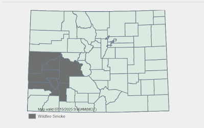
The Air Quality Health Advisory has expanded to include all of Mesa County, Hinsdale County, and San Juan County. Grand Junction, Silverton, and Lake City are now included in the advisory area.


Map of Colorado with county outlines. Advisory area shaded in gray.
An Air Quality Health Advisory is in effect for part of western Colorado.

The South RimSowbellyTurner Gulch, Wright Draw, and Deer Creek Fires are impacting air quality in western Colorado. 

The best chance for smoke is expected in areas near and downwind of the fires. Westerly to northwesterly winds are forecast for today. This means that locations east and southeast of the fires are likely to see the worst of it. 

If you are particularly sensitive to smoke, it's a good idea to take steps to protect your health today. You can stay up-to-date on the latest fire and smoke conditions on EPA's Fire and Smoke Map or InciWeb.


Monday, July 14, 2025

Wildfire smoke remains a concern for parts of western Colorado

 Hot and dry weather is doing no favors to residents in parts of western Colorado. Four wildfires will continue to pose a threat of moderate to heavy wildfire smoke to that area.  The below map from Inciweb shows the location of these four wildfires.

A map showing the location of four wildfires in western Colorado.
Location of wildfires in western Colorado and eastern Utah.  Mapping courtesy of Inciweb

  This morning's satellite image reveals some smoke across the area.  It's not overly heavy at the moment, but as the fires get more active Monday afternoon and evening there certainly could be an increase in smoke production.

A satellite image shows smoke across parts of western Colorado and eastern Utah.
Satellite imagery reveals smoke (circled in red) across parts of western Colorado and eastern Utah.  Satellite courtesy of Cooperative Institute for Research in the Atmosphere (CIRA)

The upper level transport winds will be shifting today from northerly to more westerly and decrease in intensity.  This means that the threat for wildfire smoke will decrease for locations to the south and far to the east, such as Durango, Pagosa Springs, and the San Luis Valley.  The highest threat for wildfire smoke over the next 24 hours will be for locations in close proximity to each of these fires, especially those located in or near drainages below these fires.  One other area of higher concern is in Montrose and San Miguel Counties directly downwind from the Deer Creek wildfire in Utah.  This is the largest of the fires and has the highest likelihood of producing heavy smoke today.  So a special heads up around Montrose and Telluride as it is possible smoke could head your way late in the day Monday and into Monday night.

We urge you to stay up-to-date on the very latest air quality advisories at our website.  Protecting your health is crucial during wildfire smoke episodes.  You can learn how to best protect your health at our wildfire smoke and health webpage.

Friday, July 11, 2025

Lots of smoke in Colorado on Friday, varying impacts by region

Fire activity has picked up across the west, including several new starts within Colorado. The greatest impacts are bring experienced by folks in southwestern parts of the state. Smoke from the Sowbelly Fire in southeast Mesa County, the South Rim Fire in eastern Montrose County, and the Deer Creek Fire in Utah (just west of the Colorado Border, west of Montrose County) are the primary sources of smoke locally. However several fires in other states are contributing as well.

Satellite image from 7:50 am on Friday July 11th shows smoke impacting many areas of southwestern Colorado, with heavy smoke lingering in mountain valleys. Image courtesy of CIRA/CSU.

The Air Quality Health Advisory for Wildfire Smoke has been expanded to include much of the 4-Corners/SW Colorado region. Daytime mixing of the atmosphere may decrease smoke in many areas during the day on Friday, however with hot and dry conditions expected to continue, fire activity and smoke production will likely result in similar impacts Friday night and Saturday morning; potentially continuing through the coming weekend.

Map from EPA's fire.airnow.gov shows the locations of fires and monitored smoke impacts in southwestern Colorado on Friday morning.

While our focus remains in the areas that are most severely impacted by smoke, hazy skies and light-to-moderate concentrations are possible statewide. Surface impacts will likely vary greatly from place to place and at different times throughout the day. We encourage anyone who is sensitive to fine particulate pollution to consider taking action to protect their health. Information can be found on our webpage to help determine what steps are appropriate.

We will keep a close watch on all of these incidents and will post developments and our expectations here as things progress.

Thursday, July 10, 2025

Thursday afternoon smoke update

It has been an eventful day in Colorado, to say the least. We are tracking smoke in three separate areas.

First, multiple fires have sparked in western Colorado, including the South Rim Fire. An Air Quality Health Advisory is in effect for Montrose, Delta, and southern Mesa Counties until 9 am Friday morning. 

Satellite image zoomed into western Colorado and eastern Utah. Several fire hot spots are visible across the region.
Fire hotspots (in red) on GOES-19 Satellite imagery. Multiple fires have sparked this afternoon in Colorado and Utah.


Second, smoke has moved into the Front Range. Particulate Matter concentrations in Longmont, Boulder, and Denver are starting to climb. This smoke originated from the Mount Irish Fire in Nevada. Smoke in the upper atmosphere moved into Colorado this morning. Now, that smoke has mixed down to the surface.

Third, the Mount View fire is burning north of Buena Vista. Refer to the Chafee County Sheriff's office for the latest information on evacuations. We do not expect any major public health impacts from smoke in this area. We will watch the situation and provide an update if anything changes.


If you are sensitive to smoke or near a fire, it's a good idea to take steps to protect your healthFor the most up-to-date air quality data, check out CDPHE's monitors or PurpleAir sensors.


Black Canyon wildfire

 Wildfires have broken out on both rims of the Black Canyon near Montrose.  No smoke advisories at the moment but we will continue to monitor the situation.

A band 7 infrared satellite image shows a hot spot from wildfires at Black Canyon.
Band 7 infrared satellite image shows a hot spot from wildfires at Black Canyon. Image courtesy of Colorado State University.


Smoky skies across the state on Thursday

Smoke is visible on satellite imagery, moving into Colorado from the southwest. However, it looks like this smoke hasn't yet mixed down to the ground. For the morning, smoke will remain in the upper atmosphere, but there may be a noticeable haze in the sky.

Thursday afternoon, as atmospheric mixing kicks in, smoke may mix down to the ground. Western Colorado has the highest chance of smoke reaching the surface. This includes Grand Junction, Rifle, and Steamboat Springs. 

No major public health impacts are expected at this time. People who are very sensitive to smoke may want to take steps to protect their health. We will update the blog if conditions worsen.

Satellite image of smoke (circled in red) moving into Colorado from Utah.

GOES-19 visible satellite image shows smoke (circled in red) moving into Colorado from Utah
.


Friday, July 4, 2025

Hazy skies and light smoke possible in NW Colorado

Fire activity is pleasantly minimal in much of the western U.S. at the moment. The primary incident that may have effects in Colorado is the Madre Fire in southern California. Smoke from this fire is heading our way, however the plumes that have been produced so far are not overly concerning for air quality impacts in Colorado.

Smoke may arrive in areas of northwestern Colorado on Saturday. Hazy skies and the potential for light concentrations of particulate matter are possible in areas such as Grand Junction, Steamboat Springs, and areas near Dinosaur National Monument.

Significant health impacts are not anticipated. However folks who are sensitive to particle pollution should consider taking it easy, particularly if spending time outdoors in northwestern Colorado this weekend.

Wednesday, July 2, 2025

No smoke yet for Colorado this week

 This week, Coloradans are breathing in less smoke.

Last week, smoke from fires in Colorado and Utah affected western Colorado. Fire activity is lower this week, and smoke has cleared from Colorado.

As of today, Red Flag Warnings are in effect for parts of Alaska, Washington, and Oregon. If fires spark in these upwind states, smoke could return to the conversation. We will watch for new fire starts and update the blog as necessary. 

Heading outdoors this holiday weekend? The US Forest Service has tips on how you can prevent wildfires. 


EPA's Fire and Smoke Map, zoomed out to show the continental U.S.
EPA's Fire and Smoke Map shows air quality across the Continental United States. Particulate Matter is Good to Moderate for the majority of the country.