If you would like to request a Spanish interpretation, please email cdphe_apcd_outreach@state.co.us
Si desea solicitar interpretación al español, envíe un mensaje por correo electrónico a cdphe_apcd_outreach@state.co.us
Accessibility statement and support

Friday, June 27, 2025

Smoke impacts in Colorado will vary by location on Friday

There is a lot gong on with regard to wildfires and smoke this morning. We have 2 wildfires burning in Colorado, and additional smoke being transported from out-of-state fires. Lets dig in.

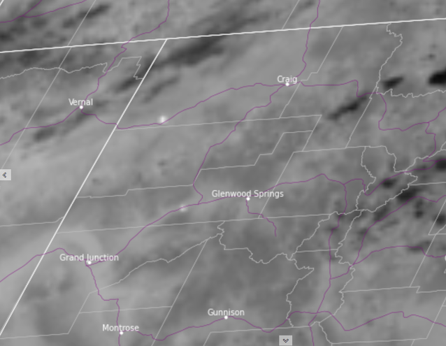
Early morning satellite imagery shows smoke and haze in many areas. Notable concentrations of smoke can be seen in valleys and lower-lying terrain on the western slope and northern mountain areas. Additional haze can be seen spilling over to areas of the Front Range. Three areas will see impacts from smoke, each to varying degrees.

Satellite image, courtesy CIRA/CSU, shows wildfire smoke in areas of northern Colorado on Friday morning. Smoke is seen in valley areas and low-lying terrain, as well as dispersed concentrations of smoke across larger areas, including the northern Front Range region. Time of image is 7:40 am MDT on 6/27/2025.

The greatest impacts from smoke will be experienced in locations near the Hilltop Fire in Garfield County. An Air Quality Health Advisory for Wildfire Smoke has been issued for areas along and near the Colorado River and I-70, from Parachute to Rulison. Smoke is expected to linger along the valley floor in this area, producing the highest concentrations of smoke during overnight and early morning hours. As daytime mixing and winds increase, smoke concentrations may decrease somewhat during the afternoon and evening hours. Folks in this area should remain aware of current and changing conditions in order to reduce exposure and potential health impacts from smoke.

Google maps image shows the general area of the Air Quality Health Advisory for Wildfire Smoke and the location of the Hilltop fire near Rulison, CO on Friday June 27, 2025.
Google maps image shows the general area of the Air Quality Health Advisory for Wildfire Smoke, and the location of the Hilltop Fire near Rulison, CO on Friday June 27, 2025.

The second area of interest for smoke impacts is in southwestern Moffat County in northwest Colorado, due to the Horse Draw fire. This fire is located in a mainly rural area of Moffat County along Highway 40, northeast of Rangely, CO. Broad public health impacts from this fire are not expected. However, higher amounts of smoke are possible in close proximity to the fire and the transport of smoke may cause hazy skies and light to moderate concentrations of fine particulates in downwind areas. These effects may reach communities such as Craig, Hayden, and Steamboat Springs. 

Lastly, there is a broad potential for the influence from smoke over large areas of northern portions of Colorado, including the northern Front Range region. Concentrations of fine particulates (smoke) are expected to remain Good to Moderate in most areas on Friday, however we will keep a close watch on air quality conditions for any potential changes. 

As always, we urge people in all areas to take appropriate measures to reduce exposure to smoke and protect your health. Information can be found on our wildfire smoke and health webpage to help decide which measures are right for you.

We will continue to provide further information and updates on all of these situations as they develop.

Thursday, June 26, 2025

2 new starts in Colorado

Two new fires have emerged on Thursday. The Hilltop fire is located in south central Garfield County, near Rulison, CO. The Horse Draw fire is in southwest Moffat County, northeast of Rangely, CO.  Information is limited on both of these fires, including location, size estimates, and extent of air quality impacts. However it is expected that areas near these fires will be impacted by moderate to heavy amounts of smoke. 

In areas near these fires, including along I-70 near Rulison, CO and along Highway 40 southwest of Maybell, CO, people who are sensitive to smoke should consider reducing exertion, and take measures to limit exposure to smoke. Health information and tips on reducing exposure can be found on CDPHE's webpage about wildfire smoke and health.


Map of northwest Colorado showing a satellite image indicating two new wildfires, 1 in southwest Moffat County and one in south central Garfield County. Image time is 6:20 pm MDT, Thursday June 26th.
Map of northwest Colorado showing a satellite image indicating two new wildfires, one in southwest Moffat County and one in south central Garfield County. Image time is 6:20 pm MDT, Thursday June 26th. Image credit CIRA/CSU.

Saturday, June 21, 2025

Watching Utah wildfires

 For the moment, air quality levels across most of Colorado have been in the Good to Moderate range as only light amounts of out-of-state wildfire smoke have arrived.  Today we will continue to monitor several fires outside of Colorado, but especially a couple of ongoing fires in southern Utah.  Any smoke that is produced at these two fires will likely carry in a northeasterly direction this afternoon and evening towards northwestern Colorado. There is a good chance the Utah wildfires will be active on Saturday due to weather conditions, and keep in mind that most of the Western Slope is under a Red Flag Warning. With that in mind, local wildfire initiation will also be a threat.

A satellite images shows two hot spots in southern Utah from local wildfires
Morning "hot spots" on satellite from southern Utah wildfires


A National Weather Service map shows most of western Colorado is under a Red Flag Warning on Saturday
Red Flag Warnings throughout western Colorado on Saturday

Thursday, June 19, 2025

Potential Smoke on Friday

People throughout Colorado may be breathing in smoke on Friday.

Models are showing smoke moving into the Western Slope on Thursday afternoon. This smoke could reach cities on the eastern Plains by Friday.

How much smoke? That depends on how much the fires grow. The France Canyon Fire, the Buck Fire, and the Trout Fire are three major fires to watch. A Red Flag Warning is in effect for parts of western Colorado, Utah, Arizona, and New Mexico. Weather conditions on Thursday and Friday could enhance these fires. If any new fires spark, they could grow quickly.

If you're sensitive to smoke, you may want to take health precautions on Thursday and Friday. 

CDPHE's website has information on how to protect your health during smoke episodes. 

Want to stay up-to-date on the air quality in your community? CDPHE's Air Quality Map and PurpleAir's Sensor Network have real-time air quality information.

We will provide an update on Friday.

Wednesday, June 18, 2025

Possible Smoke in Western Colorado Thursday

Fires in Utah and New Mexico are producing smoke that could begin to impact the Centennial State on Thursday. 

Smoke from the Buck Fire and the Trout Fire in southwestern New Mexico, and the France Canyon Fire in southwestern Utah is visible on satellite imagery.

Smoke from these fires could move into western Colorado on Thursday. Locations in southwestern Colorado, including Cortez and Durango, may wake up to hazy skies on Thursday morning. Smoke will begin to mix down to the surface Thursday afternoon across the entire Western Slope. 

People who are sensitive to particle pollution, particularly wildfire smoke, may want to take precautions on Thursday afternoon. Visit CDPHE's website for more information on how to protect your health when smoke is in the air.

Additionally, Thursday is expected to be the warmest day yet this week- temperatures are expected to be 10-15 degrees above normal, possibly hitting triple digits in Grand Junction and Palisade. CDPHE's website also has resources for how to protect your health during extreme heat.

A hot, hazy Juneteenth is in store for western Colorado- be safe out there!

Satellite image of smoke in Utah and New Mexico.
Smoke is visible in Utah and New Mexico. Image courtesy of RAMMB CIRA Slider.


Friday, June 13, 2025

Wildfires burning in several upwind states, Colorado impacts limited for now

 As summer continues to heat up, the peppered look of satellite fire detections has also flickered to life. Fires have emerged in Utah, Nevada, Arizona, and New Mexico (as well as other states and Canada), and have at times put off reasonably notable plumes of smoke. However thus far, not too much of that smoke has reached Colorado at levels that affect air quality. This is good news!

There are enough indicators that these fires are capable of growth and smoke production that motivated us to make this post, however there are other limiting factors (and some uncertainty) that helps to keep our concerns fairly low for now.

The bottom line is that hazy skies are possible for many areas of Colorado, particularly on the Western Slope. These may periodically reach the mountains and eastern plains too, yet significant health impacts look unlikely at this time. Light amounts of smoke may be experienced in areas where smoke plumes and atmospheric conditions align just right. However in the near-term these are likely to be episodic and transient.

As always, we will keep our eyes on things and will report any changes in expectations if any come about in the coming days.


Monday, June 9, 2025

Hazy start to the week for eastern Colorado

 Although the heaviest of the Canadian wildfire smoke remains to the east of Colorado, some smoke is noticeable Monday morning across the eastern half of the state.  Although widespread, significant health impacts are not anticipated at this time, you could certainly experience some mild to moderate respiratory symptoms today.  This is especially true if you suffer from any type of lung disease, such as asthma or COPD.  Please see our wildfire smoke and health webpage to learn how to best protect your health, or consult with your health provider.

The heaviest of the smoke today looks like it will impact the northeastern corner of the state, including Sterling, Holyoke and Julesburg.  Some improvement is expected by tomorrow.

A webcam image showing a hazy sky over Cheyenne Wells, Colorado
Hazy sunrise over Cheyenne Wells.  Image courtesy of Viaero weather cameras.


Saturday, May 31, 2025

Heaviest smoke stays east of Colorado

 For the time being, Colorado is avoiding the worst of the smoke impacts coming from large wildfires in Canada. The below satellite image from Saturday afternoon shows a large whirl of smoke across the central U.S. moving to the southeast.  This has kept the heavy smoke out of Colorado for the most part, with just slightly elevated fine particulate (PM2.5) levels across the northeastern corner of the state.  Some light amounts of smoke could linger overnight and possibly be pulled into the northern Front Range region by Sunday morning.  So it's not out of the question that there could be a hazy sky overhead on Sunday for Denver, Boulder, Ft. Collins and Greeley.  However, major health impacts from smoke appear unlikely at this point.

A visible satellite image showing smoke over South Dakota, Nebraska, Kansas, and other states to the east.
Visible satellite image showing smoke over South Dakota, Nebraska, Kansas, and other states to the east.


Friday, May 30, 2025

Hazy skies on Friday, limited surface impacts expected

There is good news and bad news on Friday morning. The bad news is that the plume of smoke from Canadian wildfires has reached Colorado. The good news is that the vast bulk of the smoke has remained aloft, and virtually no surface impacts have been seen as of Friday morning. We expect that hazy skies will be present over the region Friday and into Saturday, but we remain optimistic that this will be the main impacts that we see.

Satellite image from CIRA shows a plume of smoke over the Colorado Front Range and eastern plains at 8:40 am (1440 UTC) on Friday, May 30, 2025.

Satellite image from CIRA shows a plume of smoke over the Colorado Front Range and eastern plains at 8:40 am (1440 UTC) on Friday, May 30, 2025.

As the large-scale atmospheric pattern shifts eastward, the likelihood of a long-lasting transport episode decreases. However within the transport that is already underway, the possibility of seeing some of this smoke reach the surface cannot be ruled out entirely. The current outlook shows increasing surface concentrations most likely on Saturday afternoon, with AQI levels remaining in the Good to Moderate range.

Thursday, May 29, 2025

Hazy skies expected on Friday, possible light to moderate areas of smoke in E Colorado

Large wildfires in Canada are producing plumes of smoke that are moving into the U.S. Some of this smoke will move over Colorado on Friday. The bulk of the smoke is expected to remain aloft, however hazy skies are likely for areas east of the Continental Divide; including the Front Range and eastern plains of Colorado. 


Satellite image showing a smoke plume circled in red from Canadian wildfires over North Dakota and Montana
Satellite image from CIRA shows a smoke plume at 3 pm on Thursday afternoon (21Z 5/29/25, circled in red) from Canadian wildfires over North Dakota and Montana.


Although there may be significant amounts of smoke in the atmosphere above our state, only some of this smoke has a chance to reach the surface and affect air quality. Currently, models are only showing light to moderate amounts of fine particulates near the surface, possibly arriving Friday afternoon and evening. 

Map from the HRRR-Smoke model of near surface smoke at 6 pm on Friday, May 30th (00z 5/31/25) showing areas of light to moderate smoke in Colorado.
Map from the HRRR-Smoke model of near-surface smoke at 6 pm on Friday, May 30th (00z 5/31/25) showing areas of light to moderate smoke in eastern Colorado.

As of this writing (Thursday afternoon) surface impacts have not been observed in monitored values in areas where smoke may have mixed downward. A good deal of uncertainty still remains with this situation, so we will continue to monitor things as they evolve, and will continue to provide updates as they develop. We are not expecting significant public health impacts from this event, however those who are highly sensitive to smoke/particulate pollution can find info and recommendations on ways to protect your health on CDPHE's Wildfire smoke and health page.

Tuesday, May 27, 2025

San Juan National Forest Prescribed Fire- May 27, 2025

The San Juan National Forest is planning a large broadcast burn on Tuesday, May 27 near Dolores, Colorado. Smoke may be visible in Dolores, Mancos, and on highways US-160, US-491, CO-145 and CO-184.

Although no major public health impacts are expected, people who are unusually sensitive to particle pollution may want to consider reducing prolonged or heavy exertion. You can find more information on how to protect your health on CDPHE's website.

More information on this burn is available on the Prescribed Fire Map and InciWeb.

Map of San Juan National Forest. Area highlighted in yellow north of Dolores, CO is planned to burn on Tuesday, May 27.
Map of the San Juan National Forest Haycamp Mesa Prescribed Fire Area. The area highlighted in yellow denotes the location of planned ignitions on Tuesday, May 27, 2025.


Friday, May 23, 2025

Prescribed burning operations west of Colorado Springs

A prescribed burn is taking place on Friday, May 23rd near Rainbow Gulch, west of Rampart Reservoir. Smoke from this operation may be visible from areas in and near Colorado Springs. For more information, please refer to the Pikes-San Isabel National Forest X page. No public health impacts are expected, however information on smoke & your health can be found on the CPDHE information page.

Thursday, May 15, 2025

Prescribed burn operations planned for Friday, May 16th in Boulder County

Arapaho and Roosevelt National Forest managers are planning burning operations in the Forsythe II Prescribed Burn area, located 7 miles southwest of Boulder and 5 miles east of Nederland on Friday, May 16th. This portion of the Forsythe II project may burn around 125 acres. Smoke from this operation may be visible from areas along the Front Range, including Boulder, Superior, Broomfield, and surrounding areas. While smoke impacts are expected to be minimal to the public, information on how to protect your health can be found on CDPHE's Wood smoke and your health webpage.

Tuesday, April 29, 2025

Large broadcast burn on Tuesday in southwestern Colorado

 A large broadcast burn will be taking place today in Montezuma County, approximately 8 miles to the northeast of Dolores in southwestern Colorado.  Approximately 1200 acres are planned on being burned, so smoke will certainly be visible throughout the region including from Dolores, Mancos, and possibly Cortez.  Although the burn is fairly remote, some periodic smoke impacts will be possible for downwind locations Tuesday afternoon to the north and northeast of the fire in the Bald Hill and Taylor Mesa areas.  Heavier smoke will be possible overnight Tuesday night and into early Wednesday morning along Highway 145 near the fire, and also southward along the Dolores River.  It is unclear if smoke will reach Dolores overnight, but residents there should strongly consider closing their windows before going to sleep Tuesday night.  Additional ways to protect your health can be found at CDPHE's Wood smoke and your health webpage.  More information about this and other prescribed burns within the Dolores Ranger District can be accessed at the 2025 San Juan National Forest Prescribed Fire Program Inciweb page.


Location of a prescribed fire taking place on Tuesday to the northeast of Dolores, Colorado
Location of Tuesday's prescribed fire to the northeast of Dolores, Colorado


Monday, April 14, 2025

Monday prescribed fires

 Two large prescribed burns are on the calendar for Monday.  The Sunnyside controlled burn is taking place in Pitkin County with smoke likely visible today in Aspen.  In Larimer County, there is another round of burning in the Red Feather Lakes area. Any impacts from smoke should be fairly minimal around these two burns, but locally heavy smoke will not be out of the question (particularly overnight Monday night and early Tuesday morning).  For information on how to protect your health, please visit CDPHE's Wood smoke and your health webpage.  You can also see where prescribed fires are scheduled this week on the CDPHE prescribed fire map.

Sunday, April 13, 2025

Turkey Tracks Fire Burning in Douglas County

 The Turkey Tracks Fire is burning in Douglas County, approximately 8 miles north of Woodland Park. Crews have been working to limit fire spread. Find more information on fire activity at the Pike and San Isabel National Forest website.

The fire is burning in light fuels, and minimal smoke is expected. However, people nearby who are unusually sensitive to smoke may want to limit their physical activity today. We will update the blog if conditions change.

Map image of Colorado, around the Douglas/ Teller County Line. Red Pin shows location of Turkey tracks fire, approximately 8 miles north of Woodland Park, Colorado.
Pinned location (red) shows the location of the Turkey Tracks Fire, burning in Douglas County approximately 8 miles north of Woodland Park, Colorado. No major smoke impacts are expected from this fire.


Wednesday, March 26, 2025

Heavy smoke near Red Feather Lakes

 If you are planning on spending some time around Red Feather Lakes in Larimer County Wednesday morning, you may want to limit outdoor time for at least a few hours.  A 400 acre prescribed burn yesterday has produced some areas of heavy smoke this morning.  Fortunately, smoke levels are decreasing and improved air quality is expected later Wednesday morning and into the afternoon hours.  There will be some more burning in the area today, but at a much more limited scale.  Do keep in mind that smoke may be present again Thursday morning.  

Click here for more information on the Magic Feather Prescribed Burn 

Click here for the EPA's Fire and Smoke Map

Click here for information on how to protect yourself from wood smoke

A map showing an air quality monitor registering heavy smoke in the Red Feather Lakes area
An air quality monitor indicating heavy smoke (in dark red) to the east-southeast of a prescribed fire in the Red Feather Lakes area.  Data provided from EPA's Fire and Smoke Map


Tuesday, March 25, 2025

Spring Broadcast Burning

 We are entering the time of year where snow is decreasing across the state and fuels (grass, brush, etc.) are drying out, but are not dry enough (in most cases) to be a significant wildfire threat.  During this time window, conditions can become favorable for broadcast/landscape burning.  Several broadcast projects are scheduled for this week, including near Red Feather Lakes, Hudson/Keenesburg, and Alamosa.  You can stay up-to-date on the schedule of all large permitted broadcast burns at CDPHE's prescribed fire map

Firefighters maintaining the Green Mountain prescribed fire
Green Mountain Prescribed Fire
June 5, 2024
Pike & San Isabel National Forests


Thursday, March 13, 2025

Grass fire burning east of Colorado Springs airport

 A grass fire has been observed just east of Colorado Springs, as seen in the image below.

A red area on a map of south-central Colorado indicates the location of a grassfire just east of Colorado Springs.

Red area indicates a grassfire just east of Colorado Springs. Image courtesy: https://rammb-slider.cira.colostate.edu/

Breezy winds are causing the fire to spread through light fuels, but are also helping to dissipate smoke as it is lofted away from the surface by ample atmospheric mixing. Evacuation orders are in place in this area, and currently the greatest impacts from smoke are expected to remain within the evacuation area. While significant health impacts are not expected beyond the immediate vicinity of the fire, the public is urged to avoid this area as emergency crews manage the incident and evacuations take place.

We will monitor this situation and issue updates or advisories if they are warranted, as conditions change.

Monday, March 10, 2025

Intensifying wildfires in far southeastern Colorado

 A few wildfires have developed in southeastern Colorado Monday afternoon with the very dry and windy conditions.  The most intense of these fires at the moment is located along the Baca/Las Animas County line (see image below).  Although significant health impacts are not expected at this time due to the smoke lofting into the atmosphere and away from the earth's surface, you will want to avoid the area.  This includes the stretch of State Highway 160 between Kim and Springfield.  

A satellite image showing a wildfire near the Baca and Las Animas County line in southeastern Colorado


Monday, November 18, 2024

It's pile burning season!

 As we enter the winter months, the burning of piles becomes much more common across Colorado.  Snowstorms are a great time to effectively burn piles while also decreasing the amount of smoke that could cause public health issues.

Although there are several pile projects currently underway, one of the biggest ones is scheduled to start on Tuesday if conditions are optimal for burning.  It will be taking place near Keystone in Summit County where they could burn up to 900 piles on Tuesday, and perhaps additional piles on Wednesday.  Smoke will no doubt be visible in the area, including the nearby stretches of Interstate 70 and Highway 9, and the communities of Breckenridge, Silverthorne, Dillon and Frisco.

More information on pile burning in this part of Colorado can be found at the White River National Forest website.  You can also learn more about pile burning in Summit County with this video. Additionally, you can check the status of prescribed burns all across Colorado with CDPHE's prescribed fire map.  And finally, learn how you can help protect your health from woodsmoke at CDPHE's wood smoke and your health webpage.

Monday, October 28, 2024

Highland Lake wildfire

 A wildfire has started in Teller County in the Highland Lake area near Divide.  Most of the areas near the fire have been evacuated and smoke is not expected to travel far from the fire due to it's relatively small size and the alignment of nearby drainages, so major public health impacts from smoke are not anticipated.  However, you may see some smoke north of Highway 24 if you are travelling west out of Divide heading towards Florissant.  We will provide further updates if the fire does get more active.

A map showing the location of the Highland Lake wildfire a little over one mile north of State Highway 24 west of Divide in Teller County
The Highland Lake wildfire is located a little over one mile north of State Highway 24 to the west of Divide in Teller County.


Friday, October 11, 2024

Hazy skies and light to moderate smoke expected to continue this weekend

 The conditions that much of eastern Colorado and the Front Range has seen over the last several days is likely to persist, at least through the coming weekend and into early next week. A stubborn ridging pattern is in place over the southwestern U.S. and does not look like it wants to budge for the time being. This means that the clockwise flow at upper levels of the atmosphere will likely continue to carry smoke from fires burning in other states in the general direction of Colorado.

Map of the western United States shows winds at the 600 mb level moving clockwise around an atmospheric ridging pattern centered over western New Mexico.
NAM forecasted 600 mb winds at 18 UTC (12 pm MDT) on Sunday October 13, 2024, from weathernerds.com, shows a pattern that will likely continue to move smoke from out-of-state fires into Colorado over the next several days. 

What this means for us here in Colorado is that a persistence forecast will take us through the weekend. The haze that has lingered over the last few days and the up-and-down concentrations of fine particulates seen across the eastern slope of Colorado will likely continue, keeping particle pollution in the Moderate AQI category through at least Monday.

We favor these conditions over those experienced by folks who are closer to the fires and receiving much larger amounts of smoke, however we would also welcome a shift in the pattern (or some snow!) that could bring some relief from the gunk that has loitered in our area for long enough.

Keep on taking it easy if you are sensitive to smoke, keep an eye on air quality in your area, and we will keep you informed on any changes in this situation... hopefully sooner rather than later!

Wednesday, October 9, 2024

Intermittent plumes of smoke moving through the Front Range Wednesday afternoon

 As we had expected, smoke that is aloft in the atmosphere and was headed our way this morning is finding its way to the surface in areas of Colorado. In this scenario, the vertical mixing of the atmosphere is both hurting and helping us.

The low-level turbulence caused by warming daytime temperatures and our abundant Colorado sunshine, and its contrast with the relatively cooler air above the surface, is helping to draw smoke downward and is resulting in increases in particle pollution measured by surface monitors. Yet it is this same motion in the atmosphere that is creating a bank of cumulus clouds along the foothills. As the clouds move east off of the higher terrain, cooling is caused by cloud interactions with their surroundings, and helps to produce localized areas of sinking air that spreads out radially once it hits the ground. These areas of breezy outflow winds are helping to limit the overall impacts of the smoke, and are expected to help disperse surface concentrations as the afternoon progresses. Additionally, the clouds help to reduce the amount of surface heating, and decrease the vigor of up-and-down drafts, potentially limiting the amount of smoke that can be drawn down to surface level.

In addition to all of this, the dense plume of smoke that is the root of the issue continues to be fairly discrete, and is moving through the region... with emphasis on the word 'moving.'

Satellite image at 1:40 pm MDT shows a plume of smoke moving through northern and northeastern Colorado, with cumulus clouds forming along the foothills and Front Range.

Visible satellite image from CIRA shows the presence of smoke moving through the northern portions of Colorado, with cumulus clouds moving eastward off of the high terrain at 1:40 pm MDT on Wednesday afternoon. 

The overall take-away message is that we are seeing increases in particulate levels at several monitors throughout the region, but we expect those numbers to plateau and taper off as the day progresses. So while hazy skies and notable ups and downs in smoke levels are expected and taking place, we do not currently expect these conditions to persist for extended periods of time. 

As the fires continue to burn, additional plumes of smoke will be created and the potential for repetition of this cycle tomorrow does remain. Stay tuned for additional updates as we watch all of this unfold, and we will continue to share our thoughts and expectations.

Smoke will persist in areas of Colorado, with variable impacts throughout Wednesday

Smoke from out-of-state fires will continue to move into Colorado on Wednesday, mainly affecting eastern areas of the state. On Wednesday morning, surface concentrations remain in the Moderate range for many areas, with the highest numbers found on the plains and in the northeastern corner of Colorado. However higher concentrations are found in the Nebraska panhandle, and the first light images on satellite reveal the presence of smoke moving in from the northwest. The reason that the numbers shown on surface monitors do not match the location of smoke seen on satellite is because the smoke remains aloft, and has not reached the surface yet. As daytime mixing increases, we expect that smoke to be transported downward and an increase in monitored concentrations to be seen. Along with rising levels of fine particulates, degradation of visibility is also expected, causing hazy skies throughout many areas east of the Continental Divide.

Map of surface concentrations of fine particulates from PurpleAir show mainly Good (green) to Moderate (yellow) levels of smoke in Colorado, with the highest values in northeastern portions of the state.
The map of fine particulate concentrations from purpleair.com shows Good to Moderate impacts from wildfire smoke in areas of the Front Range, and in eastern and northeastern Colorado.

A large plume of wildfire smoke is seen on satellite over areas of southern Wyoming and northeastern Colorado at 8:20 am MDT on Wednesday morning, October 9, 2024.
Smoke from fires in upwind states is seen in visible satellite imagery from CIRA as it is transported southward into Colorado from Wyoming (image from 8:20 am MDT on Wednesday, October 9, 2024).


Continued transport of smoke is expected throughout the day on Wednesday. While our primary area of focus for impacts from smoke is the areas on the eastern plains, similar conditions may be seen periodically along the Front Range as well. Though the surface levels may fluctuate throughout the day and affect different areas at different times, we expect Moderate conditions to be seen in widespread areas of Colorado, reaching levels that are Unhealthy for Sensitive Groups periodically.

The Air Quality Health Advisory for the eastern plains has been continued on Wednesday, and we encourage individuals who are sensitive to smoke to take health precautions to reduce exposure, and to reduce or avoid heavy exertion in all areas where smoke is present, especially areas currently under the Advisory.

As conditions continue to evolve, updates on observed impacts and future expectations will be posted.

Tuesday, October 8, 2024

Widespread wildfire smoke across eastern Colorado

Unfortunately many eastern Colorado residents are waking up to hazy skies Tuesday morning with plenty of wildfire smoke across the region.  Alerts and advisories remain in effect for that long stretch of Interstate 25 from Pueblo northward through Colorado Springs, Denver, Ft. Collins, and to the Wyoming state line.  The good news for these areas is that there should be some steady improvement throughout the day today.  Any improvement will be slower for areas further east on the plains.  Basically for areas east of the Interstate 25 corridor and north of Interstate 70, particle pollution will likely be elevated through tomorrow morning.  You can get all the details on advisories for your area at our website.  Additionally, you can keep track of air quality monitor readings at the EPA's Fire and Smoke Map and get helpful information to protect your health at CDPHE's wildfire smoke and health webpage.

Smoky sunrise over New Raymer.  Image courtesy of https://www.viaero.com/weather-cameras


Monday, October 7, 2024

Air Quality Health Advisories/Alerts posted for parts of eastern Colorado

 With wildfire smoke now increasing across eastern parts of Colorado, Air Quality Health Advisories/Alerts have been issued.  Although increased particle pollution is anticipated throughout most of eastern Colorado, the biggest concern in the short-term is along and near the Interstate 25 corridor from the Wyoming state line southward through Ft. Collins, Denver, Colorado Springs, and as far south as Pueblo.  Expect smoke to continue to increase across the region and likely linger through at least Tuesday morning.  At this point, we do think there will be some slow improvement Tuesday afternoon but some uncertainty does continue in the forecast.  Please stay tuned here for the very latest information as the situation continues to evolve.

A webcam image showing smoke on the horizon looking northeast from Rocky Mountain Regional Airport in Broomfield
Smoke on the horizon looking northeast from Rocky Mountain Metro Airport in Broomfield. Image courtesy of the Federal Aviation Administration


Wildfire smoke headed towards northeastern Colorado

 As northerly winds spread across northeastern Colorado on Monday, wildfire smoke in Wyoming is poised to move in.  Expect particle pollution to increase throughout the region on Monday, with the areas in northeastern Colorado most impacted likely to be bounded by the Wyoming stateline to the north, the Nebraska and Kansas statelines to the east, Interstate 70 to the south, and the foothills to the west.  This will result in many towns/cities being impacted by worsening air quality on Monday, including Sterling, Ft. Morgan, Greeley, Ft. Collins, Boulder, and Denver.  Please visit CDPHE's wildfire smoke and health page for more information on how you can protect your health.

Satellite imagery showing heavy smoke in southeastern Wyoming
Visible satellite image Monday morning of heavy smoke in southeastern Wyoming

The biggest area of concern will be areas along the Interstate 25 urban corridor from Denver northward to Wyoming, along with the foothills just to the west of this stretch of Interstate 25.  This is where we could see longer duration, higher concentration smoke that could last from late Monday afternoon into Tuesday.  Advisories/Action Day Alerts may be required for this area, so please remain updated with the latest information on CDPHE's advisory webpage

Air Quality Health Advisory issued for parts of western Colorado

 Hazy skies and elevated particle pollution are greeting folks on the West Slope Monday morning.  An Air Quality Health Advisory for Wildfire Smoke has been issued for Mesa, Delta, and Montrose Counties.  With that in mind, we ask residents in these counties (particularly in valley locations, including Grand Junction, Delta, and Montrose) to take it slow this morning.  The good news is that as the atmosphere heats up this afternoon, we are anticipating surface smoke concentrations to decrease which will result in an improvement in air quality.

Photo of a hazy sunrise over Grand Junction

A hazy sunrise over Grand Junction.  Image courtesy of the Federal Aviation Administration


Sunday, October 6, 2024

Three large wildfires upwind of us are the main cause of smoke this weekend: the Yellow Lake Fire in Utah, and the Pack Trail Fire and Fish Creek Fire in Wyoming. Particulate Matter concentrations are Moderate at almost every location in Colorado. 

Today, the heaviest smoke is expected on the Western Slope, especially along the I-70 corridor. Grand Junction, Palisade, Delta, Montrose, Rifle, Glenwood Springs, and Aspen will likely see the worst of it. Expect lingering smoke overnight Sunday night into Monday on the western slope. 

As for eastern Colorado, the HRRR-Smoke model forecasts widespread smoke moving in on Monday. The smoke is expected to move in from Wyoming Monday morning, pushing south through the day on Monday and overnight into Tuesday.

For information on how to protect your health during a wildfire, visit our website.


Satellite image of Utah, Colorado, and Wyoming shows smoke (in gray) over a large area.
Satellite imagery shows smoke (in gray) visible over Utah, Colorado, and Wyoming.

The HRRR-Smoke model's near-surface smoke product shows smoke pushing through eastern Colorado on Monday.


Saturday, October 5, 2024

Smoke and Red Flag Conditions Today

We know what you're thinking - "Shouldn't fire season be over by now?" Sure, October is a little late for all this smoke and heat. While we wait for Autumn to get its act together, let's dig into today's smoke situation.

First, Smoke from the Yellow Lake Fire in Utah has moved into Western Colorado. Purple Air sensors show elevated particulate matter concentrations in Meeker, Rifle, Glenwood Springs, and Aspen. Satellite imagery shows smoke over Rio Blanco, Garfield, Mesa, Pitkin, Delta, and Gunnison counties. In these locations, you might consider limiting exercise, staying indoors, and closing your windows to reduce how much smoke you're breathing in. Additionally, you can find more tips on our website to protect your health from smoke.

Second, on the Front Range, the air is comparatively clearer, but, light smoke still lingers. Fires are still burning in Wyoming, and that smoke is still moving into Colorado. Particulate matter is expected to be in the Good to Moderate range today in Fort Collins, Greeley, Denver, and Colorado Springs.

Finally, hot, windy, and dry conditions are on tap today for a large section of Colorado. Several counties- primarily in northeast Colorado- are under a Red Flag Warning until 7 pm Saturday evening. Any new fires that spark may spread rapidly. 

CDPHE is monitoring the situation and will provide updates as necessary. 

Satellite image of Utah and Colorado. Gray smoke from a fire in Utah is visible in western Colorado and eastern Utah.
Smoke (in gray) is visible in eastern Utah and western Colorado. The eastern plains, in comparison, are much cleaner.


Friday, October 4, 2024

Outlook for the weekend brings uncertainty and conflicting expectations, in regard to smoke in Colorado

 As is often the case in Colorado, especially during the ups-and-downs that come with fall weather in our state, the weekend ahead offers a mixed bag of pros and cons with regard to smoke. Smoke and fire models have been somewhat overplaying fire activity, but also mildly underestimating particulate concentrations; making it difficult to put too much confidence in the results that they produce. 

Weather models have a bit more agreement in terms of wind and temperature patterns, however that too ushers conflicting expectations. Saturday looks to have above average temperatures, low humidity, and breezy to gusty winds. These conditions heighten concerns for fire danger. This may not mean too much in Colorado due to the pleasant lack of fire activity in our state (barring any new starts, of course). Yet the same conditions are likely to affect neighboring states like Wyoming and Utah, so the same breezy winds and good atmospheric mixing that may help to decrease the smoke that is currently lingering in pocketed areas along the Front Range may also usher in smoke from those fires that are active elsewhere, upwind from us.

A cool front looks to arrive late on Saturday and may help to lower temperatures a bit, however it will also limit vertical mixing and decrease the dispersion of any lingering smoke from transport on Saturday. Gradual warming on Monday and Tuesday will be caused by the persistence of a ridging pattern in the southwest U.S., yet may also be conducive to continued transport of smoke into our region.

The good news in all of this is that the overall concentrations of fine particulates have remained in the Good or low-Moderate range of the AQI scale, and appear to persist in a similar fashion. The takeaway message here is that while we cannot rule out some influence of smoke on our air quality, no significant impacts are expected. 

EPA's fire and smoke map shows mostly good (green) air quality throughout Colorado, with a few monitors remaining moderate (yellow) along the Front Range and eastern plains.
Though pockets of low-moderate concentrations of fine particulates linger, and may persist during the coming weekend, the map of surface air quality due to particulates (smoke) from fire.airnow.gov shows mainly good air quality in Colorado.

As always, we will keep an eye on things and put forth any pertinent information that arises.

Thursday, October 3, 2024

Smoke lingering in Colorado, overall improvement expected

The smoke that was expected to move into Colorado from the north on Wednesday moved further to the east and dispersed along the cold front that is heading our way. This spared many areas of Colorado from the higher particulate levels that appeared possible in yesterdays forecast. Great news! 

As the cold front enters Colorado from the northeast, it may push some of the smoke back toward our state and bring hazy skies and light concentrations of smoke to areas of eastern Colorado, pushing southward over the eastern plains throughout the day on Thursday.

Smoke from fires in western Wyoming made its way into areas of northwestern Colorado, and appears to be lingering in some of the mountain valleys in Routt, Grand, Moffat, Rio Blanco, and other northwestern counties. However, surface monitors still show minimal surface impacts, even in these areas.

Map of Colorado shows mainly Good (green) air quality throughout the state, with only scattered and pocketed areas of Moderate (yellow) levels of fine particulate matter,.
The map of surface air quality due to fine particulate matter (smoke) from fire.airnow.gov in the morning hours of Thursday, October 3rd, shows only light to moderate impacts from smoke, due to wildfires actively burning in other states to the north and west of Colorado.

Breezy winds throughout he day on Thursday will help to disperse the smoke that is present and limit overall concentrations from rising significantly from the current levels. Additionally, as the trough associated with the cold front moves eastward, a shift in the large-scale wind pattern looks to push things northward again, and decrease the likelihood of more smoke coming our way on Friday and into the weekend.

Though haze and light concentrations of fine particulates are expected to persist, particularly in the areas mentioned above (with some pockets of Moderate air quality remaining possible too), no significant impacts are anticipated; and the trend appears to be headed in the right direction. We will keep monitoring conditions and updating expectations as things develop, however the current outlook lets us anticipate clearing skies and fresh autumn air in the coming days.

Those that are particularly sensitive to particulate pollution may continue to consider reducing activity on Thursday, especially folks with preexisting respiratory ailments. Yet the potential for worsening conditions appears to have been avoided, and continuing improvement is expected. More info will be reported here if things change from the current outlook, but we hope that, as the old saying goes, 'no news is good news,' over the coming days.


Wednesday, October 2, 2024

Lingering Smoke With More to Come This Week

 Smoke is lingering on the Front Range this morning. Particulate matter concentrations are Moderate in Denver, Fort Collins, and Greeley. Fires continue to burn in Idaho, Utah, and Wyoming, and smoke could move into Colorado starting Wednesday afternoon.

A cold front is expected to move into Colorado on Wednesday evening, and smoke could arrive alongside it. According to the HRRR-smoke model, smoke may arrive beginning Wednesday afternoon. Counties along the Wyoming border could see smoke by late afternoon, and smoke will continue to push south Wednesday evening, and overnight into Thursday. Northern Colorado could wake up to noticeable haze and smoke on Thursday morning. Smoke may persist throughout the day on Thursday.

It's unclear exactly how much smoke will arrive, but what is clear is that northern Colorado is likely to experience the highest concentrations. Craig, Steamboat Springs, Walden, Fort Collins, Greeley, and Denver could all be impacted. If you are in these areas, you might consider limiting exercise, staying indoors, and keeping your windows shut to minimize your exposure to smoke.

We will update the blog on Thursday as conditions develop.

Visible satellite imagery shows smoke in eastern Wyoming.
Visible satellite imagery shows smoke in Wyoming, that may move into Colorado Wednesday and Thursday.


Tuesday, October 1, 2024

Front Range smoke

 Yesterday's cold front has transported smoke into the Front Range region from wildfires in Wyoming.  In fact, it is a bit more smoke that we had originally anticipated as the fires were more active yesterday that expected.  Although fine particle levels are not quite high enough for any advisories, people who suffer from heart or lung ailments in Denver, Boulder, Longmont, and Ft. Collins may want to skip that outdoor exercise this morning.  Any improvement with the air quality today will likely be slow as atmospheric mixing will not be very good.

The image shows moderate levels of particle pollution at air quality monitors throughout the Front Range region of northern Colorado
The EPA's Fire and Smoke Map shows moderate (yellow) levels of particle pollution at air sensors throughout the Front Range region


Monday, September 30, 2024

Yellow Lake fire could bring smoke to Colorado

 We will be closely watching fire activity on the Yellow Lake wildfire in northern Utah on Monday.  If the fire gets active and produces smoke, it could be sent into western Colorado tonight and during the day on Tuesday.  The image below is courtesy of the Uinta-Wasatch-Cache National Forest Facebook page where you can also get updated information on the fire's behavior.

In addition to smoke from the Yellow Lake wildfire, a cold front could bring some smoke into northwestern Colorado tonight from fires in Wyoming.  All that being said, surface concentrations of PM2.5 (fine particles, which are the primary health risk from transported wildfire smoke) could very well be elevated tonight/Tuesday from northwestern Colorado (Craig, Meeker, etc.) southward into the Grand Valley which could impact Grand Junction.  In these areas, you may want to keep an eye on air quality monitors on the EPA's Fire and Smoke Map.  If you want to play it safe, close your windows before going to sleep tonight.

We will continue to monitor the smoke and post air quality advisories here, if necessary.

Photo of the Yellow Lake wildfire with heavy smoke within an aspen and ponderosa pine forest
Photo of the Yellow Lake Fire courtesy of the US Forest Service, Unita-Wasatch-Cache National Forest Facebook page.


Wednesday, September 25, 2024

Potential for smoke moving into Colorado Thursday, 9/26/24

 While Colorado enjoys clean air and very low wildfire activity, folks in central Arizona have still been contending with smoke from the West fire, and several others in this region. The satellite image below shows a good amount of smoke emanating from the West fire on Tuesday, partially due to burning operations in order to strengthen containment lines.

Satellite image shows a large plume of smoke produced by the West fire in central Arizona on Tuesday evening, 09/24/24.
A large plume of smoke can be seen in this satellite image from the Cooperative Institute for Research in the Atmosphere, coming from the West fire, located to the east of Prescott, Arizona on the evening of Tuesday 9/24/24.

Hot and dry weather conditions may again allow for significant smoke production from the West fire (and others in this area) on Wednesday and Thursday, and an upper level ridging pattern in the atmosphere may allow for some of that smoke to be transported into Colorado. While significant health impacts are not anticipated, hazy skies and light concentrations of smoke may be present in areas on the western slope of Colorado, with these conditions possibly reaching the Front Range as well.

If conditions develop that warrant further messaging concerning this smoke and any impacts that it may have, updates will be posted here. If air quality in your area is a concern, check your local AQI on the AirNow fire and smoke map, and visit the APCD webpage for more info on particulate concentrations and health recommendations.

Monday, September 16, 2024

New wildfire start in Larimer County

 The Pearl wildfire is burning in northern Larimer County about 5 miles to the northwest of Red Feather Lakes.  Mandatory evacuations have been issued so please do heed local officials and emergency response personnel if you are in the area. Smoke concerns should be minimized due to the population being moved out and the fire's relatively small size (approximately 138 acres as of 4:10 PM MDT).  However, brief periods of heavy smoke will be possible throughout the area due to the gusty and erratic winds anticipated through this evening. 

GOES-16 satellite image of the Pearl wildfire in northern Larimer County


Saturday, September 14, 2024

Northwestern Colorado wildfire

A wildfire is located near the Moffat/Rio Blanco county line. Fortunately it is isolated and in a remote area, so should cause no public health impacts.  However you may see some smoke if you are travelling on State Highway 13 between Craig and Meeker. 

Visible satellite image of a wildfire located near the Moffat/Rio Blanco county line in northwestern Colorado


Friday, September 13, 2024

Light to moderate smoke will linger in Colorado on Friday with gradual clearing, 9/13/24

Smoke from wildfires in the western U.S. has made its way into Colorado, but thankfully, concentrations seen across the state have remained fairly tolerable. Fine particulate monitors throughout the state show good to moderate air quality, with much of the residual smoke being seen in the central mountains and along the Front Range. 

Map of fine particulate monitors in Colorado shows moderate (yellow) conditions in the central mountains of Colorado and along the Front Range region, with primarily good (green) concentrations elsewhere throughout the state.
Map of fine particulates (smoke) from fire.airnow.gov shows good to moderate air quality around the state of Colorado on Friday morning.

These conditions are likely to persist throughout the day on Friday due to a bit less wind, and atmospheric mixing that is slow to get going in the cooler air mass that has settled in. The good news is that as this air mass moves out, upper level winds will shift and limit the transport of additional smoke into our area. We expect hazy skies on Friday, with generally good to moderate air quality to remain in the current trend.

While significant public health impacts appear unlikely, those who have preexisting health conditions like asthma and COPD, and those who are sensitive to fine particulates (smoke) should continue to stay aware of the conditions in their area and consider health precautions to decrease the likelihood of adverse health effects. 

Thursday, September 12, 2024

Smoke expected to move into Colorado Thursday, into Friday... but how much? 9/12/24

Models continue to indicate that smoke from fires across the western U.S. will move into Colorado Thursday evening and into Friday, however, so far the timing and severity of those impacts has not aligned with the model's predictions. It is suspected that cloud cover and increased relative humidity within the cooler air mass that is moving through the northwest states has limited fire activity, and breezy winds are helping to disperse smoke more effectively than the model is able to account for. 

This is NOT to say that the threat of smoke moving into Colorado does not remain, it is simply to underscore the uncertainty of the timing and overall impact of this influence.

An uptick in particulate counts has been seen in in western Colorado, including in Grand Junction, where monitors are showing Moderate air quality. However the conditions seen to the west and southwest remain less concerning than anticipated. 


Moderate concentrations continue to be observed in areas of Colorado, as indicated by yellow colored dots on fire.airnow.gov. Monitors further west show orange colors, indicating thicker smoke in some areas further upwind of Colorado.
Map of fine particulate monitors from fire.airnow.gov shows mainly Moderate conditions in Colorado and areas immediately upwind. Potential remains for heavier impacts to develop, however the severe impacts shown in early model runs on Thursday have not come to pass on Thursday afternoon.


This is all very encouraging for the moment, but does not mean that we are totally in the clear. The conditions seen in areas closest to the many fires in other states confirm that smoke is still being produced, and is still likely to move toward Colorado Thursday night, and may settle in by Friday morning.

Those who are sensitive to exposure to smoke should continue to reduce heavy exertion and take precautionary measures to reduce negative health impacts from smoke. You can find information about potential health complications and ways to reduce exposure on CDPHE's website, or by clicking on the Health Information tab at the top of this blog page.

We will continue to monitor conditions closely, and will report significant changes and expectations as they emerge.