If you would like to request a Spanish interpretation, please email cdphe_apcd_outreach@state.co.us
Si desea solicitar interpretación al español, envíe un mensaje por correo electrónico a cdphe_apcd_outreach@state.co.us
Accessibility statement and support

Thursday, July 25, 2024

Transition Day

 Yet another morning of waking up to thick smoke for residents in the eastern half of Colorado.  However, today appears to be a turning point as we begin to see slow improvements.  In fact, those improvements are already occurring across the Western Slope.  Advisory information and a full analysis to come.

A webcam image of a smoky sunrise over Pueblo, Colorado
A smoky sunrise over Pueblo Thursday morning.  Image courtesy of the Federal Aviation Administration

A webcam image of some light to moderate haze over Yampa Regional Airport in Hayden, Colorado
Hazy, but improved over yesterday, at Yampa Regional Airport in northwestern Colorado.  Image courtesy of the Federal Aviation Administration


Wednesday, July 24, 2024

Heavy smoke continues for eastern Colorado. Keeping a close eye on the Western Slope.

Unfortunately we will see little to no change in smoke conditions across eastern Colorado on Wednesday.  Smoke continues to blanket the eastern half of the state which will continue to pose health concerns.  Those with heart and/or lung disease, older adults, and children will be most impacted by the poor air quality.  With that in mind, the health advisory for the eastern plains will be extended through at least 9am Thursday.  Although the entire plains are being impacted from the Wyoming to the New Mexico state lines, the further north you are, the worse the air quality is.  So take extra care if you are located in Fort Morgan, Akron, Julesburg, or any of the surrounding areas.  Our wildfire smoke and health webpage can give you tips and resources to help protect your health.

A webcam image of hazy skies over Holyoke Municipal AirportA map showing the location of Holyoke Municipal Airport in northeastern Colorado
Hazy skies over Holyoke Municipal Airport Wednesday morning.  Image courtesy of the Federal Aviation Administration

The air quality is even more troublesome as you move west towards the Interstate 25 corridor.  The mixture of wildfire smoke with typical urban pollution is producing not only bad particle pollution, but also helping to enhance ozone.  This mixture of pollution will impact not only Denver, but also Ft. Collins, Boulder, Colorado Springs and Pueblo.  Because of this, we highly suggest for residents in these urban areas (along with the adjacent foothills to the west of I-25) that suffer from heart/lung disease, older adults, and children to avoid any prolonged or heavy exertion throughout the day today and limit time outdoors.  Even those that are considered healthy should slow it down today, and while outside take extra breaks to protect your health.

A map of Colorado showing the entire eastern half of the state of Colorado with air quality advisories.
A Colorado map showing advisories by county.  Counties in purple are expecting elevated levels of both fine particulates (PM2.5) and ozone.

While all of this is going on across the eastern half of Colorado, the western half of the state is also seeing elevated levels of wildfire smoke -- but those levels are roughly 50-75% of those in eastern Colorado.  So currently there are no active advisories west of the Continental Divide.  However, we are monitoring the situation very closely as there is some smoke high up in the atmosphere over western Colorado that could mix down to the earth's surface during the late morning and afternoon hours.  If we start seeing a substantial increase in surface smoke concentrations, we will issue advisories.  It should be noted that there has been high ozone in the Grand Valley the past few days which is partially the result of wildfire smoke, so folks in the Grand Junction area should remain alert today and perhaps limit outdoor time Wednesday afternoon and evening.  Anyone can receive our air quality email alerts by signing up at our website.

So after three days of smoke, everyone is asking -- "When will this end?!?!".  Unfortunately it won't be today, but we do think we should see some gradual improvement Thursday and particularly heading into Friday.  The reason?  The upper level transport winds from the fires is finally getting cut off.  Note the upper level winds in the below graphics for today (left) vs. tomorrow (right).  Notice that the northerly wind flow coming from the Canadian fires today (left image) will push eastward onto the plains states tomorrow (right image).  With no fresh influx of wildfire smoke, the atmosphere will have an opportunity to (gradually) clean out.  We are also pleased to see that it appears the Canadian wildfires will receive at least some rainfall over the next few days.

A weather map showing Colorado being impacted by upper level winds from the north on WednesdayA weather map showing the upper level winds from the north shifting to areas east of Colorado on Thursday


The possible wild card?  If we see some new wildfire starts directly west of Colorado over the next 24 hours (central or southern California, Nevada, or Utah), we could see more smoke moving in by the weekend.  Fingers crossed that doesn't happen, but stay tuned!


An early morning look at the EPA's Fire and Smoke Map reveals fine particulate (PM2.5) concentrations in the Unhealthy for Sensitive Groups category across much of the eastern half of Colorado.  In other words, the smoke hasn't gone anywhere.........yet.  More advisories on the way today and we'll try to provide a light at the end of the smoky tunnel for you.

A map of air quality monitoring data showing elevated levels of particle pollution from wildfire smoke, especially in eastern Colorado


Tuesday, July 23, 2024

Widespread smoke across eastern Colorado. Advisories have been issued.

 A steady stream of smoke continues to pour into Colorado from the north.  The heaviest smoke today will undoubtedly be across the eastern half of Colorado with advisories posted for all areas to the east of the Continental Divide.  You can view all of our advisories on our Colorado summary page.  We also highly suggest signing up for our air quality email alerts where you can choose specific counties of which to receive alerts.  

A visible satellite image showing heavy smoke moving into eastern Colorado from the north
Visible satellite image of Canadian wildfire smoke moving into eastern Colorado.  Image courtesy of the Colorado State University SLIDER satellite page.

Although all of eastern Colorado will be impacted today, we expect the worst air quality to likely be across the northeastern corner of the state (including Julesburg, Fort Morgan and Burlington) westward to the Front Range foothills, including the entire Interstate 25 corridor from Ft. Collins southward through Denver and Colorado Springs to Pueblo.

Let's look at those two areas separately.  In the northeastern corner of the state, we are anticipating the highest particle pollution levels due to having the heaviest smoke.  We expect fine particulate concentrations (PM2.5) to increase throughout the day in this area as heavy smoke high up in the atmosphere mixes down to the earth's surface.  So even though smoke concentrations are already elevated this morning across the northeastern plains of Colorado, if you need to be outside today then this morning is probably the better option from a health standpoint.

The HRRR-smoke model showing the heaviest smoke Tuesday afternoon in the northeastern corner of Colorado
HRRR-Smoke model output showing the heaviest smoke concentrations in far northeastern Colorado Tuesday afternoon.

Meanwhile towards the foothills, it will be the combination of particle pollution and ozone that will create health concerns across the urban corridor.  All the larger cities along I-25 from Ft. Collins all the way south to Pueblo will be impacted today.  Similar to the adjacent eastern plains, the air quality is expected to get progressively worse as we move through the day.  So any outdoor activities would be best suited during the morning hours.  Better yet, if possible limit your time outdoors altogether.  Of course that is not possible for everyone, so while outside be sure to slow it down and take plenty of breaks.

The news is not all doom and gloom.  We don't expect the smoke to increase today for locations west of the Continental Divide.  In fact, we might see a little improvement in places like Granby, Steamboat Springs and Craig.  However particle pollution levels will still be elevated, so we don't advise everyone to return to normal outdoor activity levels just yet, especially if you suffer from heart or lung ailments.  We should also note that smoke may increase again across the West Slope on Wednesday as the upper level transport winds try to bring in smoke from Pacific Northwest wildfires, so please continue to remain alert to rapidly changing air quality conditions for the remainder of this week.

How to protect your health from wildfire smoke

Air quality in your area

Another smoky day on the way

 The view from the top of Pikes Peaks says it all this morning with the eastern plains completely shrouded in smoke.  Advisories will be issued this morning, so please stay tuned to this space.

A webcam image from Pikes Peak looking south showing very heavy smoke covering the eastern plains of Colorado
Webcam image from the top of Pikes Peak looking south.  Image courtesy of the city of Colorado Springs Pikes Peak Cameras


Monday, July 22, 2024

Advisories for wildfire smoke have been issued

 Wildfire smoke continues to increase across much of Colorado Monday afternoon.  Although we are seeing light to moderate levels of smoke most everywhere across the state, some heavier smoke can be found in a few areas.  The northern Front Range region (Denver, Boulder, Ft. Collins, Greeley, etc.) is one of those areas that are feeling the impacts of wildfire smoke combining with the normal, day-to-day pollution along the Interstate 25 corridor.  In fact, both ozone and particle pollution are high in this area.  You can find more information at the Front Range/Denver advisory page.  

Meanwhile, we have seen a rapid increase in wildfire smoke across north-central and northwestern parts of Colorado.  An advisory for wildfire smoke has been issued for Moffat, Routt, Jackson and Grand Counties, which includes places like Steamboat Springs and Craig.  Advisory details can be found at the Colorado advisory page.

We may see some gradual improvement across  the northwestern corner of the state on Tuesday, but that will likely not be the case east of the divide.  In fact, even heavier smoke may impact the northern Front Range region on Tuesday along with a wide expanse of the eastern plains.  Please continue to follow this blog as updates will be provided throughout this smoke episode.

In the meantime we continue to urge Coloradans to be vigiliant in protecting their health, especially those of you that may suffer from heart or lung ailments.  You can get information regarding your protecting your health at the  Wildfire smoke and your health webpage and check the air quality for your local area at the EPA's Fire and Smoke Map 

A map showing increasing levels of particle pollution from smoke across northern Colorado
EPA's Fire and Smoke Map shows moderate levels of smoke (yellow) with some areas of northern Colorado now reaching levels of smoke reaching the unhealthy for sensitive groups category (orange)


Obscured visibility at Steamboat Springs Airport due to increasing wildfire smoke.  Webcam image is provided courtesy of the Federal Aviation Administration


Smoke has arrived......and more to come

 The much advertised smoke from wildfires in Canada has arrived to Colorado and unfortunately won't be leaving in a hurry.  Highest smoke concentrations Monday morning appear to be at the higher elevation locales in north-central Colorado, including the Park Range and northern parts of the Front Range.  As evidenced by the below webcam image, Rocky Mountain National Park is already beginning to see the impacts of this smoke.

There is a good chance that health advisories will need to be issued today, particularly for parts of northern and eastern Colorado.  In the meantime, please get familiar with the best ways to prepare yourself and your loved ones for degraded air quality from wildfire smoke at our Wildfire smoke and health webpage.  Additionally, you can monitor air quality in your area with the EPA's Fire and Smoke map.

Hazy skies from the Alpine Visitor Center webcam at Rocky Mountain National Park
A smoky view from the Alpine Visitor Center webcam at Rocky Mountain National Park


Sunday, July 21, 2024

Increasing smoke statewide expected for the start of the week

 Unfortunately it is becoming increasingly likely that large parts of Colorado will see a noticeable increase in ground-level smoke concentrations over the next 24-36 hours.  To start, surface smoke levels across the northern plains states will be pushed into northeastern Colorado along with locations further southward along the Kansas stateline during the afternoon hours on Sunday.  The good news in these areas that we are also anticipating showers and thunderstorms Sunday afternoon, so smoke will be disbursed and have difficulty getting established due to the unsettled weather.

A map showing a plume of smoke and moderate particle pollution levels across North Dakota and Nebraska Sunday morning.
Canadian wildfire smoke surging into the northern plains states with data provided from the Environmental Protection Agency's Fire and Smoke Map


By Monday, a large increase in smoke aloft high up in the atmosphere is expected across large parts of the state.  This smoke could be noticeable early in the day across the north-central mountains of Colorado, including Rocky Mountain National Park, with the smoke increasing across lower elevation locations during the late morning and afternoon hours.  The heaviest smoke on Monday is expected across the eastern half of the state and could reach advisory levels, so making preparations now for degraded air quality is a good idea.  This is especially true for those that suffer from heart or lung ailments.  First and foremost, if you would like to spend some time outdoors, Sunday is without a doubt your best option for the next several days.  Additionally, checking out Wildfire smoke and health page is a good way to start planning for how to best protect your health as air quality starts to go downhill.

A visible satellite image showing heavy smoke in Canada extended southward into the northern plains states.
Sunday morning visible satellite image reveals heavy smoke extended from Canada southward into the northern plains states.


Saturday, July 20, 2024

Uncertainty remains in surface impacts from transport of wildfire smoke from out-of-state fires

 Upper level winds continue to support expectations that smoke from fires in the northwestern U.S. and Canada will move into Colorado on Sunday and into next week. However, how much of that smoke will be drawn to  the surface remains unclear. Model trends show that the greatest concentrations of smoke aloft will shift from northwestern Colorado toward northern and eastern portions of the state, possibly including the Front Range. Yet a cooler airmass is also on the way, which will bring clouds and showers to the area, and may limit much of the mixing of smoke down to the surface.

High concentrations of smoke are seen in northeastern and eastern Colorado in model output predicting smoke throughout the atmposphere on Sunday, July 21, 2024. Text at the top of the image reads Vertically Integrated Smoke, HRRR-NCEP, Valid time 20240721 20 UTC.
Pocked areas of light to moderate concentrations of smoke are seen in northeastern and eastern Colorado in model output predicting smoke near the surface on Sunday, July 21, 2024. Text at the top of the image reads Near-Surface Smoke, HRRR-NCEP, Valid time 20240721 21 UTC.
Model forecasts from the HRRR-Smoke model at 20-21 UTC (2-3pm MDT) on Sunday, July 21, 2024 show ample amounts of smoke aloft (upper image), with only pockets of light to moderate smoke reaching the surface (lower image) in northeastern Colorado (images courtesy of NOAA-NCEP).

Observations of smoke concentrations have generally agreed with model projections, so currently concerns for significant public health impacts remain minimal, however conditions may change rapidly in areas where vertical mixing enables smoke to reach the surface.
Warmer and drier conditions on Monday, with less cloud cover, may also change the vertical distribution of smoke, and may increase concerns for air quality.

We will continue to monitor this situation as it evolves, and will continue with updates and expectations as impacts become more clear. Those who are sensitive to exposure to smoke (fine particulate matter) should be prepared to undertake health precautions if conditions in your area degrade.


Friday, July 19, 2024

Weekend smoke in Colorado: Where will it be the worst?

 With upper level transport winds continuing to bring smoke into Colorado from fires in the Pacific Northwest, we do anticipate that there will be an increase in particle pollution for much of the state over the weekend.  For Saturday, it appears that the biggest impacts will be in northwestern and west-central parts of the state, so we are giving the heads up to folks in Craig, Meeker, Grand Junction, Rifle, Aspen, and surrounding areas.  Although smoke concentrations are not anticipated to reach advisory levels, it's not completely out of the question so stay tuned to this space throughout the weekend. 

It's likely that smoke will begin to increase in these impacted areas late Saturday morning and continue through the afternoon as the air mass at the earth's surface warms up and taps into the smoke that will be aloft. So if you are planning some strenuous outdoor activities on Saturday in northwestern or west-central Colorado, the earlier the better.

We are still monitoring the situation for Sunday/Monday as we could see an influx of additional smoke from fires in Canada.  More on that as the situation evolves.

A map showing increased particle pollution from smoke across northwestern and west-central Colorado
HRRR-smoke model output for 1pm MST Saturday


Thursday, July 18, 2024

Continued transport of smoke into Colorado, possibly increasing through the weekend ahead, 7/18/24

 Clockwise flow around high pressure anchored over the 4-corners area will continue to support the transport of smoke from wildfires in the northwestern U.S. In addition to this, a trough digging into the Midwest will create a corridor of upper level winds moving north-to-south along the greater Rocky Mountains over the weekend. 


Weather model forecast map of upper level winds shows winds moving southward from Canada and toward Colorado at noon MST on Saturday July 20, 2024. A large red arrow shows the path of travel along the Rocky Mountains into Colorado. Text in the upper right corner reads GFS 500 wind speed, valid 2024--7-20 18Z.
Image of GFS 500mb winds on Saturday, July 20th, 2024, courtesy Weathernerds.org.
    

This pattern is expected to continue the hazy skies and light concentrations of fine particulates that have been seen already, and may gradually increase impacts on air quality by next week. If the north-to-south transport that models are hinting at comes together, there is potential for significant degradation of conditions through the weekend, and into next week.

A computer model forecast of smoke at all levels of the atmosphere shows widespread smoke throughout the northwestern and central U.S, with heavy smoke moving south from Canada. Text at the top reads: vertically integrated smoke, HRRR-NCEP, Valid time 20240720, 18UTC
Image courtesy of NOAA NCEP.

Surface impacts that may result from the upper level transport currently remain uncertain, however there is potential for increasing levels of smoke (fine particulates) throughout Colorado. Updates will continue to be provided as things evolve and expectations become more clear.

Wednesday, July 17, 2024

More Smoke is Coming to Colorado

 After a few days of relief, smoke is coming back into the picture in Colorado later this week. Multiple large wildfires are burning in Montana, Idaho, and Oregon, producing heavy plumes of smoke in those locations. (See InciWeb for details.)

Thursday, smoke is expected to arrive in Colorado from these large fires to our north and northwest. Northern Colorado is expected to have the heaviest smoke, but light smoke is possible throughout a majority of the state. Hazy skies are also likely Thursday. While no major public health impacts are expected at this time, CDPHE will monitor the situation and issue an Air Quality Health Advisory if necessary.

Monday, July 15, 2024

New wildfire start in far western Colorado

 The Jones wildfire is producing smoke out near the Colorado/Utah state line in western Mesa County.  No public health impacts are anticipated, however you may see some smoke in the sky if you driving west out of Grand Junction on I-70 over the next few hours.

A map showing the location of the Jones wildfire in far western Colorado to the west of Grand Junction.
Location of the Jones wildfire in western Mesa County


Improving air quality.......for now

 There has been an overall decrease in the amount of fine particulate matter (PM2.5) across Colorado over the past 24 hours.  This is welcome news along with the decreasing temperatures and an increase in showers and thunderstorms that we are anticipating for today and tomorrow.  However, we will need to monitor out-of-state wildfires closely as we head towards the middle and latter part of this week with the upper-level transport winds potentially bringing an increase in smoke back to Colorado.  Stay tuned.

Sunday, July 14, 2024

Continued smoke across Colorado

If you were hoping for relief from the heat or the haze, it's not here just yet. Smoke is sticking around for another day. Most will remain primarily in the upper atmosphere, so expect another day of hazy skies and light to moderate smoke at the surface today. Afternoon highs are again expected to climb into the high 90s and low 100s. The extreme heat can exacerbate the effects of air pollution on the body, so take caution to protect your health. CDPHE's website has resources on how to protect your health during extreme heat and how to stay healthy during a wildfire smoke event. 

The good news? Some thunderstorm activity is possible Sunday afternoon. While it might not be enoough rainfall to water your garden, the shakeup from this stagnant weather pattern could help to clear the air a bit.

One difference today is that a Red Flag Warning is in effect for a large portion of Colorado, and our neighbors upwind (Wyoming, Utah, Idaho, Nevada, and more.) The smoke situation could change if new fires spark. CDPHE is monitoring the situation and will provide updates as necessary. 


webcam view of downtown Denver facing west, with haze covering the view of the mountains

Another hazy day in Colorado. This webcam faces west, showing downtown Denver with the mountains in the background. Today, haze blocks the view of the Rockies. (Image from APCD webcam: https://www.colorado.gov/airquality/live_image.aspx)

Saturday, July 13, 2024

Quail Hollow Fire Burning Southeast of Byers

The Quail Hollow fire is burning in Arapahoe County, southeast of Byers. Because this fire is burning in low density fuels (brush, grass, etc.) it is unlikely that it will produce heavy amounts of smoke. No major public health impacts are expected at this time. However, unusually sensitive people may consider reducing time outdoors in areas where smoke is present. 

Visible satellite image of Colorado with county outlines. Smoke, circled in red, is visible.

Smoke from the Quail Ridge Fire is visible on satellite. Source: https://rammb-slider.cira.colostate.edu/ 

Dinosaur Fire update

 Fire crews did an outstanding job containing the Dinosaur Fire which started yesterday in close vicinity to south Boulder and the National Center for Atmospheric Research laboratories.  We issued an Air Quality Health Advisory for Wildfire Smoke yesterday in anticipation of smoke draining from the fire overnight into south Boulder.  Fortunately, it appears the smoke is not overly heavy as evidenced by several air quality monitors located below the fire reading only light to moderate levels of fine particulate matter (PM2.5).  Therefore, we will allow the advisory for southern Boulder County to expire this morning at 9am.  However, we will continue to monitor the Dinosaur Fire and all potential fire starts around the state throughout the weekend.  The air quality is already compromised due to transported smoke from out-of-state wildfires, so additional smoke from in-state wildfires could quickly make air quality conditions much worse.

A map showing the location of the Dinosaur Fire with nearby air quality monitors showing light to moderate levels of smoke.
Air quality monitoring near the Dinosaur Fire in south Boulder.  Data provided by the Environmenal Protection Agency's Fire and Smoke Map


Hazy start to a hot weekend

Hazy skies are greeting Coloradoans Saturday morning as the view from the top of Copper Mountain attests.  A conveyor belt of smoke continues to be transported from distant fires in California, Oregon, Washington and Idaho into Colorado.  Although smoke concentrations are not overly heavy, health impacts could still be noticeable due the extreme heat we are experiencing.  Additionally, high ozone is anticipated in the northern Front Range region Saturday afternoon, particularly in and near the Denver metro area.

We do anticipate some of the higher smoke levels to settle into the northern Front Range region, including Denver, Boulder, Ft. Collins, Greeley, and surrounding areas, during the afternoon hours on Saturday.  You may notice the visibility around the area degrade during the afternoon and perhaps you may experience some symptoms associated with increasing levels of fine particulate matter (PM2.5).  

Individuals with heart and/or lung disease should remain especially cautious this weekend and remain indoors during the hottest part of the day when both the heat and air quality will likely be at it's worst.  Even those that are considered healthy should consider making changes to their scheduling of active outdoor time, if possible.  The morning hours or towards sunset would be the better options for getting outside for any type of exercise.

The good news?  It appears the upper level winds will begin to shift late in the weekend and early in the work week which will cut off the flow from out-of-state wildfires.  So better air air quality will likely coincide with the cooler temperatures that are also expected to arrive.

Picture of hazy skies on top of Copper Mountain
Hazy sunrise from the top of Copper Mountain.  Image courtesy of the Federal Aviation Administration


Friday, July 12, 2024

Dinosaur Fire burning in Boulder County

The Dinosaur Fire, near the National Center for Atmospheric Research (NCAR) just southwest of Boulder, was reported this afternoon. Smoke is visible from Boulder. In the afternoon, smoke will likely loft into the upper atmosphere, but as the sun begins to set and daytime mixing decreases, smoke will settle in the nearby areas. South Boulder may experience moderate to possibly heavy smoke on Friday night into Saturday morning.

An Air Quality Health Advisory for Wildfire Smoke is in effect until at least 9 am Saturday for Boulder County. While the smoke itself is not expected to cause widespread public health impacts, there are other factors at play which can worsen the health effects of smoke. The fire's proximity to a large population center, the ongoing Ozone Action Day Alert, and extreme heat in the forecast can all enhance the health effects of smoke. If you are sensitive to heat or smoke, it's best to stay indoors and avoid heavy exercise.

For more information on how to protect your health, CDPHE's website has resources for protecting your health during extreme heat and protecting your health during a wildfire smoke event, and the effects of ozone pollution on your health.

Smoke from the Dinosaur Fire, near the National Center for Atmospheric Research, is visible from Boulder.
Smoke from the Dinosaur Fire is visible from Boulder. (Source: City of Boulder Disaster Management)


Smoke and Extreme Heat in Store for the Weekend

Here comes the smoke... and heat. This week, much of the western US has experienced extreme heat, and thick smoke. A high pressure ridge situated over the West has been the primary cause of this unrelenting weather. That ridge is moving into Colorado, bringing a heat wave and smoky skies.

On Friday, smoke is expected to move into northern and western Colorado. While most of this smoke will remain in the upper atmosphere, some may mix down to the surface, primarily in northern Colorado. Light to moderate smoke is possible in counties along the Colorado/ Wyoming border. However, most locations will notice hazy skies with limited impacts to air quality.

Smoke is expected to increase this weekend throughout the entire Front Range. Light to moderate smoke is possible from Fort Collins to Pueblo on Saturday. Currently, no major public health impacts are expected, but CDPHE will issue and Air Quality Health Advisory for Wildfire Smoke if conditions worsen.

In addition to the smoke, much of eastern Colorado will experience temperatures above 100 degrees this weekend. The National Weather Service has issued a Heat Advisory for many counties on the Front Range and the eastern Plains.

Very hot temperatures along with smoke may exacerbate health issues in sensitive individuals. If you are sensitive to either heat or smoke, reduce your time outdoors, if possible. CDPHE's website has information for how to protect your health during extreme heat and how to protect your health during a wildfire smoke event.


Visible satellite imagery shows smoke  in Oregon, Idaho, and Montana, which is expected to move into Colorado Friday and Saturday. (Source: https://rammb-slider.cira.colostate.edu/)

Thursday, July 11, 2024

Smoke Set to Arrive in Colorado Today

Moderate to heavy smoke has blanketed much of North America this week, and today Colorado is expected to join the party. The ridge of high pressure which has been situated over the western United States will shift eastward towards Colorado today. 

Smoke will begin to trickle in to northwestern Colorado by late Thursday morning, and continue spreading eastward as the day goes on. The majority of smoke will remain in the upper atmosphere, although some will mix down to the surface. Hazy skies are likely across much of northern and western Colorado. Light to moderate smoke is possible Thursday in northwest Colorado, especially Steamboat Springs, Craig, and Meeker. 

No major public health impacts are expected today, but if you are unusually sensitive to smoke, you may consider limiting your time outdoors, and avoid heavy exercise if possible.

To stay up-to-date on smoke levels in your area, see CDPHE's monitoring network, EPA's fire and smoke map, or Purple Air.

EPA's fire and smoke map shows smoke plumes over OR, WA, ID, MT, ND, SD,
EPA's fire and smoke map shows moderate to heavy smoke across a large area of the western United States. (Source: www.fire.airnow.gov)

Wednesday, July 10, 2024

Smoke Transport Wednesday and Thursday

This week, while many Americans have suffered poor air quality due to wildfire smoke, Coloradans have enjoyed much cleaner air. That may change in the coming days. An upper-level ridge of high pressure has been situated over the western United States, but this ridge will shift eastward towards Colorado late Wednesday into Thursday, bringing smoke along with it.

Light to moderate smoke is possible on Thursday beginning in northwestern Colorado, and moving southward and eastward to encompass most of northern and western Colorado. Most of this smoke will remain aloft, so the skies may look hazy on Thursday. Light to moderate smoke may be possible if smoke mixes down to the surface.

No major public health impacts are expected this time. If conditions change and smoke becomes heavy, CDPHE will issue an Air Quality Health Advisory.

Satellite image of the western and midwestern US shows smoke over states upwind of Colorado. Red arrows point at smoke in Utah and the Dakotas.

Satellite imagery shows heavy smoke is upwind of Colorado, and is expected to move into the state by Thursday. (Source: https://rammb-slider.cira.colostate.edu/)

Monday, July 8, 2024

Colorado's close call with Canadian smoke

 The first few frames of the visible satellite image reveal extensive wildfire smoke across the northern plains states.  Fortunately for Colorado, the bulk of the smoke should remain east of the state for the time being.  However, some hazy skies and light surface smoke will be possible today across the northern half of the state.  Significant health impacts are very unlikely, but if you are unusually sensitive to smoke you may want take it a bit slower today and keep your windows closed if you notice smoke in the area.

A satellite image showing heavy smoke over parts of South Dakota and Nebraska.


Saturday, July 6, 2024

Canadian smoke for Colorado?

 Massive wildfires continue to burn in northern parts of British Columbia.  A cold front that will bring much cooler weather to parts of Colorado on Sunday could also usher in some smoke from these fires on Monday.  It's too early to know specific details yet, but we will be closely monitoring the fires and upper level winds over the next couple of days for possible Colorado impacts.

A satellite image of smoke plumes from large wildfires in northern British Columbia


Friday, July 5, 2024

Oak Ridge fire update, 7/5/24

 The Oak Ridge Fire continues to burn near the Pueblo/Custer County line, approximately 3 miles northwest of Beulah. Smoke impacts have remained minimal over the last several days with limited fire/smoke activity observed. Friday afternoon and evening, fire managers plan to initiate burning operations that will reinforce fire lines and aid in containment efforts. Due to these operations, smoke production is expected to increase, and light to moderate smoke may be present in areas near the fire, possibly reaching Beulah to the east, and Westcliffe to the west. While no significant public health impacts are expected, health precautions are recommended for those who are sensitive to smoke exposure, in areas where smoke is apparent.


For additional information and updates on the operations on this fire, visit the InciWeb page for the Oak Ridge fire.

Thursday, June 27, 2024

Oak Ridge fire update, 6/27/24

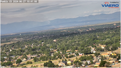
 The Oak Ridge fire is now estimated at 1,008 acres and continues to burn near the Pueblo/Custer County line, approximately 3 miles northwest of Beulah, CO. Firefighting operations "hit it hard" on Wednesday, deploying fire retardant via airborne resources, enabling additional ground operations to take place and slow the fire's spread. Smoke impacts were minimal on Thursday morning, and with increased cloud cover and relative humidity expected on Thursday, the Air Quality Health Advisory for Wildfire Smoke was allowed to expire.

Thunderstorms are possible in this area on Thursday afternoon. These may aid firefighting operations and limit fire activity and smoke production, however thunderstorms also may produce gusty, erratic winds that can send smoke in any direction. CDPHE/APCD will closely monitor smoke conditions, and may re-issue an advisory if concerns for public health increase.

Smoke will remain present in areas in the immediate vicinity of the fire, and individuals who are unusually sensitive to smoke are encouraged to take health precautions in areas where smoke is apparent.

Communities in the foreground are mixed among deciduous trees. Mountains in the background frame a column of smoke rising from the Oak Ridge wildfire, lofting vertically away from the surface. Text in the upper left of the image reads Pueblo, CO 2024-06-27, 10:41:00. Text in the upper right reads Furnished by: Viaero Wireless.
Image courtesy of Viaero Wireless.

For additional information and updates visit the InciWeb page for this fire.

Wednesday, June 26, 2024

Oak Ridge Fire Update, Wednesday 6/26

The Oak Ridge Fire grew westward on Tuesday, and is now burning along the Pueblo/ Custer County line. For the most up-to-date information on fire growth, visit InciWeb.

On Wednesday, smoke will likely dissipate throughout the day as atmospheric mixing picks up. There is a possibility of afternoon thunderstorms, which could send smoke in any direction. After the thunderstorms move through and the wind dies down, smoke will begin to settle. Smoke may become moderate to heavy overnight Wednesday into Thursday morning, especially in Beulah.

Map of the perimeter of the Oak Ridge fire, showing that the perimeter of the fire has grown into Custer County.
Map showing the estimated perimeter of the Oak Ridge Fire.


Tuesday, June 25, 2024

Oak Ridge Fire 6/25

The Oak Ridge Fire is burning in Pueblo County, approximately 3 miles northwest of Beulah. Dry thunderstorms are possible through Tuesday evening, with gusty, erratic winds that could send smoke in any direction. Smoke may become heavy overnight Tuesday into Wednesday morning, especially along Middle Creek which could result in moderate to heavy smoke in Beulah.

Visit InciWeb for the most up-to-date information on the Oak Ridge Fire.


Smoke visible from the oak ridge fire burning in heavy fuels
Smoke from the Oak Ridge Fire.


Thursday, June 13, 2024

Smoke impacts have decreased on the Interlaken fire on Thursday, 6/13/24

Smoke impacts have decreased greatly on Thursday morning in areas near the Interlaken wildfire in southern Lake and northern Chaffee counties. Due to lower risks for public health, the Air Quality Health Advisory will be allowed to expire at 9 am on Thursday. Light winds and good atmospheric mixing are expected to loft smoke away from the surface on Thursday, resulting in minimal public health impacts. CDPHE/APCD will continue to monitor fire activity and smoke production, and will re-issue advisories for smoke if concentrations increase. Light to moderate concentrations of smoke may linger in lower terrain in areas near Twin Lakes, particularly during the overnight and early morning hours. Health precautions should be considered by groups who are unusually sensitive to exposure to smoke (fine particulate matter).

Light concentrations of smoke linger in a wide valley, with mountains in the background. Text at the top of the image reads, Bald Mountain (N), 14:10 06/13/24 (UTC),  8:10 06/13/24 (MDT). Text at the bottom of the image reads, FAA advisory weather product.
Light concentrations of smoke are present near Buena Vista on Thursday morning. Image courtesy of Federal  Aviation Administration.

Prescribed fire near Monument continues on Thursday

 The US Forest Service is continuing a prescribed burn project on Thursday with a treatment of up to 400 acres possible.  There have been some heavy smoke impacts from Wednesday's burn on areas just to the east of the burn site in western parts of the Monument area.  Fortunately that smoke is starting to clear out Thursday morning, though another round of smoke will be possible later today and early Friday morning.  For residents in this area, please keep windows close when smoke is present and avoid or reduce any strenous activities.

Picture of smoke lofting into the sky from the Monument prescribed burn.
Smoke from the Monument prescribed fire on June 12, 2024


Wednesday, June 12, 2024

Heavy morning smoke near the Interlaken Fire

 It's a rough morning for air quality at Twin Lakes Wednesday morning with heavy smoke settling overnight from the Interlaken Fire.  The smoke has also spread southwards along the Arkansas River and State Highway 24 into Americus and Buena Vista.  It's unclear at this point how much additional fire activity can be expected today, but regardless the Air Quality Health Advisory that was issued last night for southern Lake and northern Chaffee Counties will be re-issued and will run through at least 9am Thursday.

Heavy smoke along the Arkansas River Valley.  Image courtesy of the Federal Aviation Administration


Tuesday, June 11, 2024

Air Quality Health Advisory issued for the Interlaken wildfire in southern Lake County, 6/11/24

An Air Quality Health Advisory has been issued for the Interlaken wildfire, burning in southern Lake County, approximately 5 miles northwest of Granite, Colorado. Smoke from this fire is visible along Highway 24 near Twin Lakes, and between Leadville and Buena Vista. Health precautions should be taken in this area, especially for those who are sensitive to smoke (fine particulate matter). 


Silhouettes of trees are seen against a background of red and orange flames with billows of smoke rising above . White text reads Air Quality Health Advisory: Wildfire Smoke. The logo for the Colorado Department of Public Health and Environment is in the lower left corner.

Wednesday, June 5, 2024

Prescribed Fire near Green Mountain

 A prescribed fire is taking place today near Green Mountain in the Pike-San Isabel National Forest. No major public health impacts are expected from this fire, but smoke may be visible as far away as Chatfield State park on Wednesday evening through Thursday morning. In areas where smoke is present, unusually sensitive people should consider reducing prolonged or heavy exertion.


Thursday, May 23, 2024

Smoke from the Spruce Creek wildfire affecting areas in southwest Colorado, 5/23/24

 Smoke from the Spruce Creek wildfire will again affect areas in southwest Colorado on Thursday and Friday. The image shows smoke early Thursday morning affecting areas near the fire. As winds shift throughout the day, and smoke is transported by upper level winds, additional impacts are possible in downwind areas on Thursday afternoon.

The Air Quality Health Advisory for Wildfire Smoke  has been continued for this area. Areas of heavy smoke are present in many areas on Thursday morning, especially along State Highway 145 south of Rico to Dolores. This smoke is expected to lift throughout the day on Thursday as daytime atmospheric mixing deepens and winds increase. Winds out of the west or southwest will transport smoke to areas to the east or northeast of the fire on Thursday afternoon, possibly creating impacts in those areas, including Telluride, Ouray, Silverton, Lake City, and Creede. The greatest impacts from smoke are expected overnight Thursday night and early Friday morning as smoke settles throughout the advisory area, especially in lower terrain and sheltered mountain valleys.

Additional information about this fire can be found on InciWeb. 


Satellite image shows smoke in areas of southwestern Colorado. A large red arrow points to areas of heaviest smoke, and red text reads Smoke.
A satellite image from May 23 shows smoke near the Spruce Creek Fire. Image courtesy of RAMMB CIRA.

Wednesday, May 22, 2024

Spruce Creek Fire

 The Spruce Creek Fire continues! Crews are managing the perimeter of this fire to contain it to an area that is 4,500 acres in total. Latest measurements estimate the fire at just over 1,800 acres, and crews expect the fire to grow around 1,500 to 2,000 acres a day. More information on the firefighting strategy can be found on InciWeb. 

Winds out of the southwest are expected on Wednesday, meaning smoke will be transported towards communities northeast of the fire. This includes Rico, Telluride, Lake City, and other communities along R-145. 

Overnight Wednesday into Thursday morning, smoke will settle in low-lying areas such as valleys and creeks. Heavy smoke is possible overnight in Dolores, as well as drainages along Lost Canyon Creek, and the Haycamp Mesa Foothills.

When smoke is present, it is best to stay indoors and avoid exercise. Looking for more information on how to protect your health? Visit CDPHE's website.


In the foreground, two aspen trees flank the left and right sides of this phot, while in the background, the Spruce Creek fire burns through Ponderosa Pines, Gambel Oaks, and Apsens across the road.
The Spruce Creek Fire is burning in a forest of mostly Ponderosa Pine, Gambel Oak, and Aspen Trees. Image Courtesy of US Forest Service.

Monday, May 20, 2024

Prescribed Burning near Gross Reservoir

The US Forest Service conducted a 70 acre prescribed burn on Sunday in the vicinity of Gross Reservoir in Boulder County.  Although no additional ignitions are expected for the next several days, lingering smoke will be likely in the area.  

Sign up here for email updates regarding this burn.

Additional information about the Forsythe II prescribed burn can be found here on InciWeb.

A map of the Forsythe II prescribed burn area near Gross Reservoir in Boulder County, Colorado
 Map of the Forsythe II Prescribed Burn area. Image courtesy of US Forest Service.

Spruce Creek Fire

The Spruce Creek wildfire is located in Montezuma County approximately 11 miles northeast of Dolores within the San Juan National Forest. This is a low to moderate intensity wildfire which is being closely monitored by the US Forest Service and is not anticipated to produce any significant public health issues to local areas.  However, smoke will likely be visible along Colorado Highway 184 between Mancos and Dolores with some light to moderate smoke possible at times around the area, mainly during the early morning hours.  For more information on this fire, please visit InciWeb.

Satellite image showing a glowing hot spot in northeastern Montezuma County of southwestern Colorado.
Satellite imagery from May 20 shows a hot spot, indicating the location of this fire in Montezuma County.

Monday, May 13, 2024

Canadian Wildfires

Heavy smoke is impacting the upper midwest Monday morning with highly elevated levels of fine particulates (PM2.5), particularly in Minnesota and Wisconsin.  This smoke is originating from wildfires in Alberta of western Canada.  Fortunately for Colorado residents, the bulk of the smoke should remain far to north and northeast for the time being with only some light smoke possible in far eastern parts of Colorado near the Nebraska and Kansas state lines. No public health impacts are anticipated.

A map showing high levels of fine particulates from smoke across northern parts of the United States, especially Minnesota and Wisconsin.
The EPA's Fire and Smoke Map shows higher concentrations of PM2.5 across the upper Midwest on May 13, 2024. No public health impacts are anticipated in Colorado.


Tuesday, April 23, 2024

Prescribed Burning Operations taking place in eastern La Plata County, 4/23/24

 A large prescribed burning operation is taking place on Tuesday, April 23, 2024 in La Plata County, just east of Bayfield. Smoke from this operation may be visible from locations near Highway 160 in eastern La Plata County and western Archuleta County. No significant public health impacts are currently expected.

Monday, April 15, 2024

Prescribed Burning in Arapaho Roosevelt National Forest, week of 4/15

This week, a prescribed burn is anticipated to take place in the Forsythe II burn area, west of Gross Reservoir in western Boulder County. While no major public health impacts are expected, smoke may be visible in nearby locations. Unusually sensitive people should consider reducing prolonged or heavy exertion in areas where smoke is visible.

Updates on this burn will be posted to InciWeb.


Broadcast burn on a slope with coniferous trees in the background
Broadcast burning is taking place at the Forsythe II burn area. Image courtesy of US Forest Service.

Prescribed burning operations to take place just west of Boulder on Monday, 4/15/24

 Prescribed burning operations are planned to take place on the Forsythe II Prescribed Burning Project on Monday, April 15th. This project is located just west of Boulder, near Gross Reservoir. Smoke from these operations my be visible from locations near Boulder and along the Colorado Front Range on Monday. While no significant public health impacts are expected, unusually sensitive people should consider reducing prolonged or heavy exertion in areas where smoke is apparent on Monday.